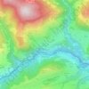
Mittersill topographic map
Click on the map to display elevation.
Mittersill
It has traffic links running east to west and north to south. The Felbertauern road tunnel runs south through the Hohe Tauern at an elevation of about 1630 m, providing a connection with Lienz in East Tyrol. To the north lies the Thurn Pass at an elevation of 1274 m, providing a connection with Kitzbühel and Tyrol.
About this map
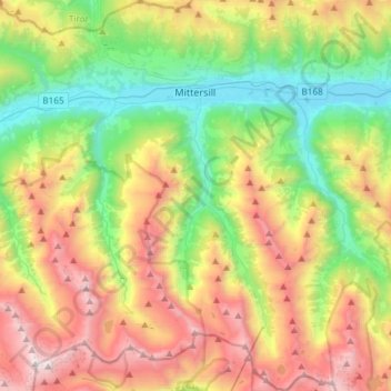
Name: Mittersill topographic map, elevation, terrain.
Location: Mittersill, Bezirk Zell am See, Salzburg, 5730, Austria (47.12761 12.37437 47.32862 12.56636)
Average elevation: 1,729 m
Minimum elevation: 769 m
Maximum elevation: 3,213 m
Other topographic maps
Click on a map to view its topography, its elevation and its terrain.


Eibing
Austria > Salzburg > Bezirk Zell am See > Saalbach-Hinterglemm > Saalbach
Average elevation: 1,344 m

Hasenau
Austria > Salzburg > Bezirk Zell am See > Saalbach-Hinterglemm > Hinterglemm
Average elevation: 1,386 m

Großvenediger
Austria > Salzburg > Bezirk Zell am See > Neukirchen am Großvenediger
Average elevation: 3,179 m
Großes Wiesbachhorn
Austria > Salzburg > Bezirk Zell am See > Fusch an der Großglocknerstraße
Average elevation: 2,879 m


Königsleiten
Austria > Salzburg > Bezirk Zell am See > Gemeinde Wald im Pinzgau
Average elevation: 1,703 m
Sankt Martin bei Lofer
Austria > Salzburg > Bezirk Zell am See > Gemeinde Sankt Martin bei Lofer
Average elevation: 913 m
Hohlwegen
Austria > Salzburg > Bezirk Zell am See > Saalfelden am Steinernen Meer
Average elevation: 1,106 m

Schmalenbergham
Austria > Salzburg > Bezirk Zell am See > Saalfelden am Steinernen Meer > Thor
Average elevation: 784 m