
Morgins topographic map
Interactive map
Click on the map to display elevation.
About this map
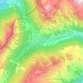
Name: Morgins topographic map, elevation, terrain.
Location: Morgins, Troistorrents, Monthey, Valais, 1875, Suisse (46.21766 6.83810 46.25766 6.87810)
Average elevation: 1,566 m
Minimum elevation: 1,113 m
Maximum elevation: 2,034 m
Située à 1 350 mètres d'altitude, Morgins fait partie du domaine skiable des Portes du Soleil. Le village situé dans le Val de Morgins vit principalement des activités touristiques.
Other topographic maps
Click on a map to view its topography, its elevation and its terrain.
Revereulaz
Suisse > Valais > Monthey > Torgon
Revereulaz, Torgon, Vionnaz, Monthey, Valais, 1899, Suisse
Average elevation: 898 m
Bonne-Année
Suisse > Valais > Monthey > Vionnaz
Bonne-Année, Vionnaz, Monthey, Valais, 1895, Suisse
Average elevation: 825 m
Chenarlier
Suisse > Valais > Monthey > Troistorrents
Chenarlier, Troistorrents, Monthey, Valais, Suisse
Average elevation: 923 m
Troistorrents
Troistorrents, Monthey, Valais, Suisse
Average elevation: 1,231 m
Val-d'Illiez
Val-d'Illiez, Monthey, Valais, 1873, Suisse
Average elevation: 1,672 m