
Nangang District topographic map
Interactive map
Click on the map to display elevation.
About this map
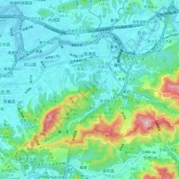
Name: Nangang District topographic map, elevation, terrain.
Location: Nangang District, Taipei, Taiwan (25.01226 121.57771 25.06460 121.66594)
Average elevation: 75 m
Minimum elevation: -6 m
Maximum elevation: 368 m
Other topographic maps
Click on a map to view its topography, its elevation and its terrain.
Yangmingshan National Park
Unlike most other national parks, the Yangmingshan National Park has a lower elevation. Although the park's elevation ranges from only 200–1120 meters, beautiful landscapes such as ridges, valleys, lakes, waterfalls, and basins are abundant. Andesite rocks make up most of the area's geology.
Average elevation: 397 m