
Nuevo León topographic map
Interactive map
Click on the map to display elevation.
About this map
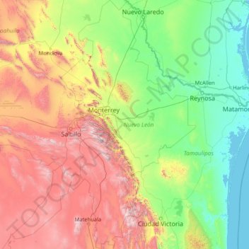
Name: Nuevo León topographic map, elevation, terrain.
Location: Nuevo León, Mexico (23.16267 -101.20676 27.79914 -98.42158)
Average elevation: 805 m
Minimum elevation: -2 m
Maximum elevation: 3,623 m
Nuevo León's geography is known for englobing three of the most important physiographic provinces of the northeast region. The south end of the Great Plains is considered to start in the northernmost regions of Nuevo León. The region is characterized by the soft hills that dominates the lands neighboring the banks of the Rio Grande. The south and west of the state consists of the Sierra Madre Oriental mountain range, which dominates most of the western scenery. Due to the abrupt shape of the mountains, there are vast valleys in between the mountains. Within these valleys is where the city of Monterrey and its metropolitan area is situated. The Northern Gulf Coastal Plains are located to the east and include low altitude lands; it is classified as an "inclined plain" due to the alluvial land.
Other topographic maps
Click on a map to view its topography, its elevation and its terrain.
Querétaro
Mexico > Querétaro > Municipio de Querétaro
Querétaro, Municipio de Querétaro, Querétaro, Mexico
Average elevation: 1,921 m
Fuerte de Guadalupe
Mexico > Puebla > Cuautlancingo > Barrio de Nuevo León
Fuerte de Guadalupe, Barrio de Nuevo León, Cuautlancingo, Puebla, 72770, Mexico
Average elevation: 2,154 m
Cancún
Mexico > Quintana Roo > Benito Juárez
Cancún, Benito Juárez, Quintana Roo, Mexico
Average elevation: 5 m
Sabinas Hidalgo
Sabinas Hidalgo, Nuevo León, 65270, Mexico
Average elevation: 457 m
Loreto
Mexico > Baja California Sur > Municipio de Loreto
Loreto, Municipio de Loreto, Baja California Sur, 23880, Mexico
Average elevation: 22 m
Zacatecas City
Mexico > Zacatecas > Municipio de Zacatecas
Zacatecas City, Municipio de Zacatecas, Zacatecas, 98000, Mexico
Average elevation: 2,290 m
Sombrerete
Mexico > Zacatecas > Sombrerete
Sombrerete, Zacatecas, 99100, Mexico
Average elevation: 2,401 m
Laguna Verde
Mexico > Veracruz > Angel R. Cabada
Laguna Verde, Angel R. Cabada, Veracruz, Mexico
Average elevation: 148 m
Puerto Cortés
Mexico > Baja California Sur > Municipio de Comondú
Puerto Cortés, Municipio de Comondú, Baja California Sur, Mexico
Average elevation: 6 m
Cabo San Lucas
Mexico > Baja California Sur > Los Cabos Municipality
Cabo San Lucas, Los Cabos Municipality, Baja California Sur, 23470, Mexico
Average elevation: 94 m
Barrabás
Mexico > Guerrero > Cutzamala de Pinzón
Barrabás, Cutzamala de Pinzón, Guerrero, Mexico
Average elevation: 414 m
Tlalnepantla
Mexico > State of Mexico > Tlalnepantla de Baz
Tlalnepantla, Tlalnepantla de Baz, State of Mexico, 54000, Mexico
Average elevation: 2,358 m
Colonia Centro
Mexico > Baja California Sur > Municipio de Mulegé
Colonia Centro, Municipio de Mulegé, Baja California Sur, Mexico
Average elevation: 68 m
Las Pintitas
Las Pintitas, El Salto, Región Centro, Jalisco, 45693, Mexico
Average elevation: 1,539 m
El paso
Mexico > Guerrero > Tecoanapa > Los Saucitos
El paso, Los Saucitos, Tecoanapa, Guerrero, Mexico
Average elevation: 626 m
San Miguel de Allende
Mexico > Guanajuato > San Miguel de Allende
San Miguel de Allende, Guanajuato, Mexico
Average elevation: 1,964 m
Guadalajara
Mexico > Jalisco > Guadalajara
Guadalajara, Jalisco, 44360, Mexico
Average elevation: 1,572 m
Rancho Nuevo
Rancho Nuevo, Terrenos del Lote "San Miguel Mecatepec", Tihuatlán, Veracruz, 92933, Mexico
Average elevation: 82 m
Parque Juarez
Mexico > Veracruz > Santiago Tuxtla > La Cuchilla
Parque Juarez, La Cuchilla, Santiago Tuxtla, Veracruz, Mexico
Average elevation: 216 m
Parque Juárez
Mexico > Puebla > Tehuacán > Tehuacán
Parque Juárez, Tehuacán, Puebla, Mexico
Average elevation: 1,628 m
Amatenango del Valle
Mexico > Chiapas > Amatenango del Valle
Amatenango del Valle, Chiapas, Mexico
Average elevation: 1,976 m
Yucatán Peninsula
Mexico > Quintana Roo > Othón P. Blanco
Yucatán Peninsula, Othón P. Blanco, Quintana Roo, Mexico
Average elevation: 100 m
Corales
Mexico > Guerrero > Técpan de Galeana
Corales, Técpan de Galeana, Guerrero, Mexico
Average elevation: 491 m