Geolocate

Atlacomulco topographic map

Interactive map

Click on the map to display elevation.

Atlacomulco

The municipality has rugged terrain, filled with mountains and hills. It is located on the Trans-Mexican Volcanic Belt, in the Lakes and Volcanos of Anáhuac region. Principle elevations include Cerro Xitije, Cerro Atlacomulco, Cerro La Cruz and Cerro El Cielito. Its altitude varies from 2720 to 3030 meters above sea level. It is part of the Lerma River basin which crosses the territory, as well as a number of streams and fresh-water springs. There three dams in the area, with the main one being J. Trinidad Fabela. Its climate is fairly moist with most rain falling between June and September. Average high temperatures is 19.9C and average low is 7.4C.

Wikipedia (CC-BY-SA 3.0)

About this map

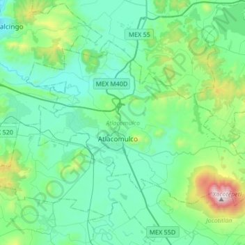
Name: Atlacomulco topographic map, elevation, terrain.

Location: Atlacomulco, State of Mexico, Mexico (19.73033 -99.97420 19.90158 -99.70513)

Average elevation: 2,665 m

Minimum elevation: 2,395 m

Maximum elevation: 3,898 m

Other topographic maps

Click on a map to view its topography, its elevation and its terrain.

Valle de Bravo

Mexico > State of Mexico > Valle de Bravo

The municipality is surrounded by mountain ranges and other elevated areas covering about 50% of the total area and include the Sierra de Temascaltepec, Sierra de Tenayac, Sierra de Valle de Bravos as wells as the hills that roll around the mountain ranges. These elevations include a number of small volcanoes…

Average elevation: 1,914 m

Cerro Gordo

Mexico > State of Mexico > Valle de Bravo

Average elevation: 2,169 m

Malinalco

Mexico > State of Mexico

As municipal seat, the town of Malinalco is the governing authority over 54 other named communities, which covers an area of 186.28km2. The municipality, which shares its name with the seat, has a population of 22,970 of which only 6,523 live in the town of Malinalco. It has an average elevation of 1750 meters…

Average elevation: 1,871 m

Chalco

Mexico > State of Mexico

Average elevation: 2,654 m

Cuautitlán Izcalli

Mexico > State of Mexico

Average elevation: 2,312 m

Metepec

Mexico > State of Mexico

Metepec (Spanish: [meteˈpek] ) is a municipality in the State of Mexico in Mexico and is located directly to the east of the state capital, Toluca, at an altitude of 2,635 metres (8,645 ft) above sea level. The center of Mexico City lies some 50 km further to the east. The city of Metepec also form part of…

Average elevation: 2,625 m

Ojo De Agua

Mexico > State of Mexico > Temoaya > Enthavi

Average elevation: 2,879 m

Texcoco de Mora

Mexico > State of Mexico > Texcoco

Tescoco lies about 25 km east of the centre of Mexico City. Major elevations in the municipality include the Tlaloc Mountain (4,500 meters) the Tetzcutzinco, Moyotepec and Tecuachacho. Most elevations are named after the major community to be found on them. There are also a number of small canyons. Part of the…

Average elevation: 2,448 m

Ciudad Satélite

Mexico > State of Mexico

Average elevation: 2,451 m

Coacalco de Berriozábal

Mexico > State of Mexico

Average elevation: 2,353 m

Ixtapaluca

Mexico > State of Mexico

Average elevation: 2,473 m

Tlalnepantla

Mexico > State of Mexico > Tlalnepantla de Baz

Average elevation: 2,358 m

San Antonio la Isla

Mexico > State of Mexico

Average elevation: 2,585 m

Lerma

Mexico > State of Mexico

The municipality's territory is irregular with rolling hills leading up to the Sierra de Las Cruces mountain range, which extend from north to south on the east side of the municipality. In this range, there are a number of steep valleys, such as Salazar. Most of the residents are found in the foothills of the…

Average elevation: 2,788 m

Naucalpan de Juárez

Mexico > State of Mexico

The highest peaks are the Organo and La Malinche mountains at 3,650 metres (11,980 feet) above sea level. Other notable elevations include la Cantera, El Cedral, San Joselito, La Plantación and Peña del Rayo. The main rivers through the area include the Totolina, San Lorenzo and Los Remedios. Water supply…

Average elevation: 2,366 m

Acolman

Mexico > State of Mexico

The municipality is located on a plain in the northern portion of the Valley of Mexico called the Valley of Teotihuacan. It has only three significant elevations. The eastern border is marked by the Sierra de Patlachique and the west is marked by a mountain called Chiconautla. Chiconautla and Tlahuilco are…

Average elevation: 2,298 m

Tlalnepantla de Baz

Mexico > State of Mexico

Average elevation: 2,323 m

Huitznahuac

Mexico > State of Mexico > Chiautla

Average elevation: 2,253 m

Isidro Fabela

Mexico > State of Mexico

Average elevation: 3,073 m

Temascalcingo

Mexico > State of Mexico

The town today has an altitude of 2,380 meters and in 2005 had a population of 11,454 people. The town is centered on a square called the Plaza Centenario, with its Municipal Palace to the south of the square. To the north is another, smaller square dedicated to painter José María Velasco.

Average elevation: 2,603 m

Jilotzingo

Mexico > State of Mexico

Average elevation: 2,968 m

Eje Neovolcánico

Mexico > State of Mexico > Amecameca

Volcanic ash make soils in the region very fertile, which (especially coupled with elevation making tropical climate milder) has led to high human population densities in the belt that now sometimes strain the environment.

Average elevation: 4,179 m

Chicoloapan

Mexico > State of Mexico

Average elevation: 2,326 m

Nezahualcóyotl

Mexico > State of Mexico

The municipality has a territory of 63.44 km2, 81% of which is occupied by the city, which consists of 86 neighborhoods called colonias. The rest is part of the Federal Zone of the Ex-Basin of Texcoco. The municipality is flat with only one elevation reading 1,220 meters above sea level. The Los Remedios and a…

Average elevation: 2,235 m

Tepexpan

Mexico > State of Mexico

Average elevation: 2,266 m

Teotihuacán

Mexico > State of Mexico

Average elevation: 2,346 m

San Franciso de Asís

Mexico > State of Mexico

Average elevation: 890 m

Toluca

Mexico > State of Mexico > Toluca

The Lerma River flows from Lake Almoloya del Río through the center of the municipality towards the west, flowing into Lake Chapala. From this point westward the river takes the name of Río Grande de Santiago. And it goes from this lake to the Pacific Ocean in the state of Nayarit. The river is about 1,180…

Average elevation: 2,729 m

Rio San Juan

Mexico > State of Mexico > Teotihuacán > Teotihuacán

Average elevation: 2,261 m

Santiago Tianguistenco

Mexico > State of Mexico > Tianguistenco

The municipality lies in the Trans-Mexican Volcanic Belt in the sub-province of the Lakes and Volcanoes of Anahuac. 35% of the municipality is mountainous, 30% is arable and the rest is developed. The topography of the municipality varies due to its size. The eastern portions are highest as they are in the…

Average elevation: 2,645 m

Popocatépetl

Mexico > State of Mexico > Atlautla

Average elevation: 4,810 m

Teotihuacán

Mexico > State of Mexico > Teotihuacán

Average elevation: 2,311 m

Chapa de Mota

Mexico > State of Mexico > Chapa de Mota

Average elevation: 2,636 m

Ciudad Adolfo Lopez Mateos

Mexico > State of Mexico > Atizapán de Zaragoza > Ciudad Adolfo Lopez Mateos

Its main elevations are Biznaga Hill, Atlaco Hill La Condesa Hill and Grande Hill.

Average elevation: 2,426 m

Valle de Bravo

Mexico > State of Mexico

Average elevation: 2,072 m

San Franscisco

Mexico > State of Mexico > San Franscisco

Average elevation: 2,829 m

Atizapán

Mexico > State of Mexico > Atizapán

Average elevation: 2,582 m

Tonatico

Mexico > State of Mexico > Tonatico

Tonatico has several nearby mountains, including La Cruz and Tapachichi. The largest is La Puerta at 1,685 meters of elevation. The Salto de Zumpantitlán waterfall is nearby, along with the Tenancingo, San Geronimo and Taplalla rivers.

Average elevation: 1,617 m

Ojo de Agua

Mexico > State of Mexico > Zinacantepec > Ojo de Agua

Average elevation: 3,051 m