Geolocate

Agta topographic map

Click on the map to display elevation.

About this map

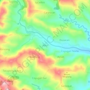
Name: Agta topographic map, elevation, terrain.

Location: Agta, Iloilo, Western Visayas, Philippines (10.80884 122.32012 10.84884 122.36012)

Average elevation: 222 m

Minimum elevation: 115 m

Maximum elevation: 376 m

Other topographic maps

Click on a map to view its topography, its elevation and its terrain.

Zarraga

Philippines > Iloilo

Average elevation: 10 m

Oton

Philippines > Iloilo > Oton

Average elevation: 11 m

Estancia

Philippines > Iloilo > Estancia

Average elevation: 11 m

Leganes

Philippines > Iloilo

Average elevation: 9 m

Pavia

Philippines > Iloilo

Average elevation: 15 m

Miagao

Philippines > Iloilo

Average elevation: 97 m

Gear up for your next adventure:

🍲Portable Camping Stoves - Fast-boiling stoves for hot meals on remote topographic survey trips
🗺️Ordnance Survey Maps - Official UK maps for walking and outdoor activities
🔦Outdoor Torches - Reliable torches for night navigation
🦟Anti-Midge & Tick Repellent - Vital for hiking in the Scottish Highlands during summer
🧵Survival Paracord - Multi-purpose cordage for emergency repairs and shelters

As an Amazon Associate, this site earns from qualifying purchases at no extra cost to you.