
Masanhappo-gu topographic map
Interactive map
Click on the map to display elevation.
About this map
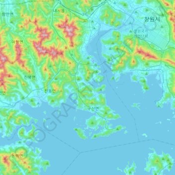
Name: Masanhappo-gu topographic map, elevation, terrain.
Location: Masanhappo-gu, Changwon-si, South Gyeongsang, South Korea (35.03340 128.34795 35.22241 128.65878)
Average elevation: 92 m
Minimum elevation: -7 m
Maximum elevation: 737 m
Other topographic maps
Click on a map to view its topography, its elevation and its terrain.
Pyeong-am-ri
Pyeong-am-ri, Changwon-si, South Gyeongsang, South Korea
Average elevation: 350 m
Jinhae-gu
Jinhae-gu, Changwon-si, South Gyeongsang, South Korea
Average elevation: 82 m