
Sugar Hill topographic map
Interactive map
Click on the map to display elevation.
About this map
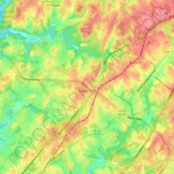
Name: Sugar Hill topographic map, elevation, terrain.
Location: Sugar Hill, Gwinnett County, Georgia, United States (34.06466 -84.10169 34.15187 -84.01418)
Average elevation: 332 m
Minimum elevation: 277 m
Maximum elevation: 383 m
According to the United States Census Bureau, as of 2010 the city of Sugar Hill had a total land area of 10.6 square miles (27.5 km2), of which 0.04 square miles (0.1 km2), or 0.33%, was water. The U.S. Geological Survey lists the city's elevation as 1,149 feet (350 m).
Other topographic maps
Click on a map to view its topography, its elevation and its terrain.
Buford
United States > Georgia > Gwinnett County
Buford, Gwinnett County, Georgia, United States
Average elevation: 340 m
Lilburn
United States > Georgia > Gwinnett County
Lilburn, Gwinnett County, Georgia, United States
Average elevation: 291 m
Norcross
United States > Georgia > Gwinnett County
Norcross, Gwinnett County, Georgia, 30071, United States
Average elevation: 309 m
Northwest Harbor
United States > Georgia > Gwinnett County > Buford
Northwest Harbor, Buford, Gwinnett County, Georgia, 30158, United States
Average elevation: 340 m
Suwanee
United States > Georgia > Gwinnett County
Suwanee, Gwinnett County, Georgia, United States
Average elevation: 311 m
Duluth
United States > Georgia > Gwinnett County
Duluth, Gwinnett County, Georgia, United States
Average elevation: 305 m
Sweet Water Park
United States > Georgia > Gwinnett County
Sweet Water Park, Regency Woods, Sweet Water, Gwinnett County, Georgia, United States
Average elevation: 292 m
Snellville
United States > Georgia > Gwinnett County > Snellville
Snellville, Gwinnett County, Georgia, United States
Average elevation: 300 m
Lawrenceville
United States > Georgia > Gwinnett County
Lawrenceville, Gwinnett County, Georgia, United States
Average elevation: 312 m