
Make a donation
Gear up for your next adventure:
As an Amazon Associate, this site earns from qualifying purchases at no extra cost to you.
Saint-Hubert topographic map
Click on the map to display elevation.
Make a donation
Gear up for your next adventure:
As an Amazon Associate, this site earns from qualifying purchases at no extra cost to you.
Saint-Hubert
Le Galata, altitude 589 m., point culminant de la commune est aussi celui du plateau de Saint-Hubert, un des « sommets » du massif (schisteux-rhénan) ardennais. Il se situe à l'est de la ville, au bord de la base aérienne EBSU. Il est accessible via le hameau de Hurtebise (monastère bénédictin), juste à côté du Radar des Ardennes (Belgocontrol).
Make a donation
Gear up for your next adventure:
As an Amazon Associate, this site earns from qualifying purchases at no extra cost to you.
About this map
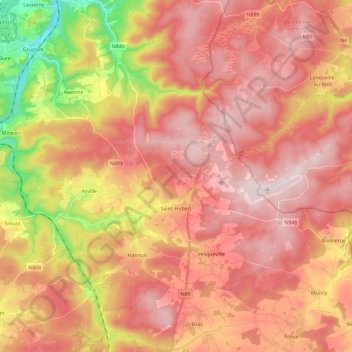
Name: Saint-Hubert topographic map, elevation, terrain.
Location: Saint-Hubert, Neufchâteau, Luxembourg, Wallonie, 6870, Belgique (49.97975 5.22916 50.09592 5.46034)
Average elevation: 451 m
Minimum elevation: 217 m
Maximum elevation: 589 m
Make a donation
Gear up for your next adventure:
As an Amazon Associate, this site earns from qualifying purchases at no extra cost to you.
Other topographic maps
Click on a map to view its topography, its elevation and its terrain.
Make a donation
Gear up for your next adventure:
As an Amazon Associate, this site earns from qualifying purchases at no extra cost to you.
Make a donation
Gear up for your next adventure:
As an Amazon Associate, this site earns from qualifying purchases at no extra cost to you.
Make a donation
Gear up for your next adventure:
As an Amazon Associate, this site earns from qualifying purchases at no extra cost to you.
Bouillon
Belgique > Luxembourg > Neufchâteau > Bouillon
Entourée de forêts, la ville s’étend dans et autour d’un méandre accentué de la Semois, un affluent de la Meuse. L'altitude y est d'environ 220 mètres. Elle est desservie par la route nationale 83 menant à Arlon, route qui borde la ville à l’est et qui se confond sur le territoire communal avec…
Average elevation: 338 m
Make a donation
Gear up for your next adventure:
As an Amazon Associate, this site earns from qualifying purchases at no extra cost to you.
Make a donation
Gear up for your next adventure:
As an Amazon Associate, this site earns from qualifying purchases at no extra cost to you.
Make a donation
Gear up for your next adventure:
As an Amazon Associate, this site earns from qualifying purchases at no extra cost to you.
Make a donation
Gear up for your next adventure:
As an Amazon Associate, this site earns from qualifying purchases at no extra cost to you.
Make a donation
Gear up for your next adventure:
As an Amazon Associate, this site earns from qualifying purchases at no extra cost to you.
Make a donation
Gear up for your next adventure:
As an Amazon Associate, this site earns from qualifying purchases at no extra cost to you.
Make a donation
Gear up for your next adventure:
As an Amazon Associate, this site earns from qualifying purchases at no extra cost to you.
Make a donation
Gear up for your next adventure:
As an Amazon Associate, this site earns from qualifying purchases at no extra cost to you.
Make a donation
Gear up for your next adventure:
As an Amazon Associate, this site earns from qualifying purchases at no extra cost to you.
Make a donation
Gear up for your next adventure:
As an Amazon Associate, this site earns from qualifying purchases at no extra cost to you.
Make a donation
Gear up for your next adventure:
As an Amazon Associate, this site earns from qualifying purchases at no extra cost to you.
Réserve Naturelle des Anciennes Troufferies de Libin
Belgique > Luxembourg > Neufchâteau > Recogne
Average elevation: 439 m
Make a donation
Gear up for your next adventure:
As an Amazon Associate, this site earns from qualifying purchases at no extra cost to you.
Make a donation
Gear up for your next adventure:
As an Amazon Associate, this site earns from qualifying purchases at no extra cost to you.
Sainte-Marie-Chevigny
Belgique > Luxembourg > Neufchâteau > Saint-Marie-Chevigny
Average elevation: 497 m
Make a donation
Gear up for your next adventure:
As an Amazon Associate, this site earns from qualifying purchases at no extra cost to you.
Sainte-Marie-Chevigny
Belgique > Luxembourg > Neufchâteau > Saint-Marie-Chevigny
Average elevation: 497 m
Make a donation
Gear up for your next adventure:
As an Amazon Associate, this site earns from qualifying purchases at no extra cost to you.
Le Tombeau du Géant
Belgique > Luxembourg > Neufchâteau > Bouillon > Botassart
Average elevation: 300 m
Make a donation
Gear up for your next adventure:
As an Amazon Associate, this site earns from qualifying purchases at no extra cost to you.