
Thunderbolt topographic map
Interactive map
Click on the map to display elevation.
About this map
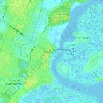
Name: Thunderbolt topographic map, elevation, terrain.
Location: Thunderbolt, Chatham County, Georgia, United States (32.02093 -81.06394 32.04606 -81.02741)
Average elevation: 5 m
Minimum elevation: -4 m
Maximum elevation: 14 m
Other topographic maps
Click on a map to view its topography, its elevation and its terrain.
Savannah
United States > Georgia > Chatham County
Savannah, Chatham County, Georgia, United States
Average elevation: 4 m
Oakdale
United States > Georgia > Chatham County > Savannah
Oakdale, Savannah, Chatham County, Georgia, 31406, United States
Average elevation: 10 m
Welwood
United States > Georgia > Chatham County > Savannah
Welwood, Savannah, Chatham County, Georgia, 31409, United States
Average elevation: 7 m
Tybee Island
United States > Georgia > Chatham County
Tybee Island, Chatham County, Georgia, 31328, United States
Average elevation: 1 m
O'Leary
United States > Georgia > Chatham County > Port Wentworth > O'Leary
O'Leary, Port Wentworth, Chatham County, Georgia, 31407, United States
Average elevation: 5 m