
Mount Bethel topographic map
Interactive map
Click on the map to display elevation.
About this map
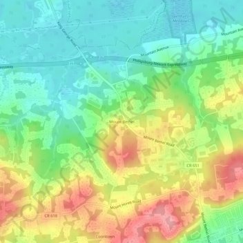
Name: Mount Bethel topographic map, elevation, terrain.
Average elevation: 107 m
Minimum elevation: 60 m
Maximum elevation: 178 m
Other topographic maps
Click on a map to view its topography, its elevation and its terrain.
Hillsborough Township
United States > New Jersey > Somerset County
Hillsborough Township, Somerset County, New Jersey, United States
Average elevation: 46 m
Green Brook Township
United States > New Jersey > Somerset County
Green Brook Township, Somerset County, New Jersey, 08812, United States
Average elevation: 66 m
Rocky Hill
United States > New Jersey > Somerset County
Rocky Hill, Somerset County, New Jersey, 08553, United States
Average elevation: 35 m
Bradley Gardens
United States > New Jersey > Somerset County
Bradley Gardens, Bridgewater Township, Somerset County, New Jersey, 08869, United States
Average elevation: 28 m
Round Top
United States > New Jersey > Somerset County
Round Top, Warren Township, Somerset County, New Jersey, 08836, United States
Average elevation: 128 m
Raritan
United States > New Jersey > Somerset County
Raritan, Somerset County, New Jersey, 08869, United States
Average elevation: 26 m
Somersetin
United States > New Jersey > Somerset County > Bernardsville
Somersetin, Bernardsville, Somerset County, New Jersey, 07924, United States
Average elevation: 184 m
Bound Brook
United States > New Jersey > Somerset County
Bound Brook, Somerset County, New Jersey, 08805, United States
Average elevation: 24 m
Green Knoll
United States > New Jersey > Somerset County > Bridgewater Township
Green Knoll, Bridgewater Township, Somerset County, New Jersey, 08807, United States
Average elevation: 63 m
Bedminster
United States > New Jersey > Somerset County
Bedminster, Bedminster Township, Somerset County, New Jersey, 07931, United States
Average elevation: 67 m
Manville
United States > New Jersey > Somerset County > Manville > Manville
Manville, Somerset County, New Jersey, 08835, United States
Average elevation: 22 m
Bernardsville
United States > New Jersey > Somerset County
Bernardsville, Somerset County, New Jersey, United States
Average elevation: 142 m
Branchburg Township
United States > New Jersey > Somerset County
Branchburg Township, Somerset County, New Jersey, United States
Average elevation: 42 m
Peapack-Gladstone
United States > New Jersey > Somerset County > Peapack-Gladstone
Peapack-Gladstone, Somerset County, New Jersey, United States
Average elevation: 106 m
Montgomery Township
United States > New Jersey > Somerset County
Montgomery Township, Somerset County, New Jersey, United States
Average elevation: 53 m
Coontown
United States > New Jersey > Somerset County
Coontown, Warren Township, Somerset County, New Jersey, 07059, United States
Average elevation: 121 m
Milltown
United States > New Jersey > Somerset County
Milltown, Branchburg Township, Somerset County, New Jersey, 08876, United States
Average elevation: 34 m
Liberty Corner
United States > New Jersey > Somerset County > Bernards Township > Liberty Corner
Liberty Corner, Bernards Township, Somerset County, New Jersey, 07920, United States
Average elevation: 85 m
Skillman
United States > New Jersey > Somerset County > Skillman
Skillman, Montgomery Township, Somerset County, New Jersey, 08504, United States
Average elevation: 56 m
Springdale
United States > New Jersey > Somerset County > Springdale
Springdale, Warren Township, Somerset County, New Jersey, 07059, United States
Average elevation: 103 m
Weston
United States > New Jersey > Somerset County > Manville > Weston
Weston, Manville, Somerset County, New Jersey, 08835, United States
Average elevation: 18 m
North Branch Depot
United States > New Jersey > Somerset County > North Branch Depot
North Branch Depot, Branchburg Township, Somerset County, New Jersey, 08876, United States
Average elevation: 38 m
Lamington
United States > New Jersey > Somerset County > Lamington
Lamington, Bedminster Township, Somerset County, New Jersey, 08858, United States
Average elevation: 54 m
Bernards Township
United States > New Jersey > Somerset County > Bernards Township
Bernards Township, Somerset County, New Jersey, United States
Average elevation: 105 m
North Plainfield
United States > New Jersey > Somerset County > North Plainfield
North Plainfield, Somerset County, New Jersey, United States
Average elevation: 43 m
Basking Ridge
United States > New Jersey > Somerset County
Basking Ridge, Bernards Township, Somerset County, New Jersey, 02794, United States
Average elevation: 98 m
Watchung
United States > New Jersey > Somerset County
Watchung, Somerset County, New Jersey, 07069, United States
Average elevation: 92 m
Franklin Township
United States > New Jersey > Somerset County
Franklin Township, Somerset County, New Jersey, United States
Average elevation: 31 m
Bridgewater Township
United States > New Jersey > Somerset County
Bridgewater Township, Somerset County, New Jersey, United States
Average elevation: 58 m
Far Hills
United States > New Jersey > Somerset County
Far Hills, Somerset County, New Jersey, United States
Average elevation: 100 m
Millstone
United States > New Jersey > Somerset County
Millstone, Somerset County, New Jersey, United States
Average elevation: 22 m