
Ratingen topographic map
Interactive map
Click on the map to display elevation.
About this map
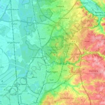
Name: Ratingen topographic map, elevation, terrain.
Location: Ratingen, Kreis Mettmann, North Rhine-Westphalia, Germany (51.26453 6.80124 51.37179 6.98309)
Average elevation: 71 m
Minimum elevation: 27 m
Maximum elevation: 168 m
Other topographic maps
Click on a map to view its topography, its elevation and its terrain.
Abtsküche / Haus Hetterscheidt
Germany > North Rhine-Westphalia > Kreis Mettmann > Heiligenhaus > Tüschen
Abtsküche / Haus Hetterscheidt, Tüschen, Heiligenhaus, Kreis Mettmann, North Rhine-Westphalia, 42579, Germany
Average elevation: 168 m
Wülfrath
Germany > North Rhine-Westphalia > Kreis Mettmann
Wülfrath, Kreis Mettmann, North Rhine-Westphalia, 42489, Germany
Average elevation: 187 m
Langenfeld (Rheinland)
Germany > North Rhine-Westphalia > Kreis Mettmann
Langenfeld (Rheinland), Kreis Mettmann, North Rhine-Westphalia, 40764, Germany
Average elevation: 55 m
Haan
Germany > North Rhine-Westphalia > Kreis Mettmann > Haan
Haan, Kreis Mettmann, North Rhine-Westphalia, 42781, Germany
Average elevation: 149 m
Hilden
Germany > North Rhine-Westphalia > Kreis Mettmann
Hilden, Kreis Mettmann, North Rhine-Westphalia, Germany
Average elevation: 55 m
Erkrath
Germany > North Rhine-Westphalia > Kreis Mettmann
Erkrath, Kreis Mettmann, North Rhine-Westphalia, Germany
Average elevation: 81 m
Velbert
Germany > North Rhine-Westphalia > Kreis Mettmann
Velbert, Kreis Mettmann, North Rhine-Westphalia, Germany
Average elevation: 172 m
Mettmann
Germany > North Rhine-Westphalia > Kreis Mettmann
Mettmann, Kreis Mettmann, North Rhine-Westphalia, 40822, Germany
Average elevation: 149 m