
Fergana District topographic map
Interactive map
Click on the map to display elevation.
About this map
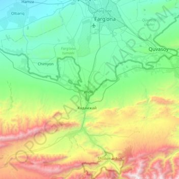
Name: Fergana District topographic map, elevation, terrain.
Location: Fergana District, Fergana Region, Uzbekistan (39.93373 71.41510 40.42799 71.98158)
Average elevation: 1,272 m
Minimum elevation: 430 m
Maximum elevation: 3,744 m
Other topographic maps
Click on a map to view its topography, its elevation and its terrain.
Shohimardon
Uzbekistan > Fergana Region > Fergana District
Shakhimardan City Resort is situated at 1975m above sea level, 155 km from Ferghana, in the picturesque mountainous district. The Kuliqurbon or Blue Lake is seven kilometers southeast of Shakhimardan. It was formed in 1766 after a series of extreme earthquakes. The lake is located at an altitude of 1,724…
Average elevation: 1,790 m