
Ban Kliang topographic map
Interactive map
Click on the map to display elevation.
About this map
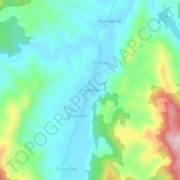
Name: Ban Kliang topographic map, elevation, terrain.
Location: Ban Kliang, Na Haeo, Loei Province, Thailand (17.42533 101.03627 17.46533 101.07627)
Average elevation: 571 m
Minimum elevation: 481 m
Maximum elevation: 826 m
Other topographic maps
Click on a map to view its topography, its elevation and its terrain.
Phu Ruea
The Phu Ruea High Altitude Agricultural Research Station is on the mountain and Phu Ruea National Park encompasses the peak. The park borders Sainyabuli province in Laos at its northern end. Most of the mountain is covered in mixed evergreen forest. The area around the mountain is part of the Luang Prabang…
Average elevation: 752 m