
Racovița topographic map
Interactive map
Click on the map to display elevation.
Racovița
Racovița Commune is situated at the base of Suru Peak (2,281 m or 7,484 ft) on the contact between the foothills of the Făgăraș Mountains and the low terrace of the floodplain, on the left bank of the river Olt, at an altitude of 385 meters. The commune borders to the north and northeast with the town Avrig; the border, which extends from the confluence of the small river Mârșa with the Olt to the Sorliței Peak, was established after the year 1200 and is marked with border signs called 'morminți'.
About this map
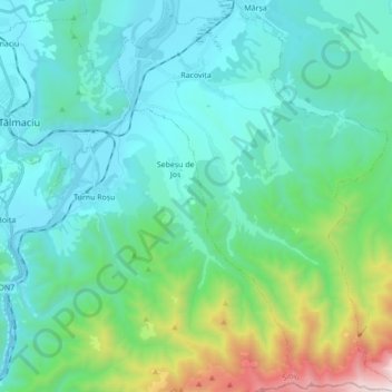
Name: Racovița topographic map, elevation, terrain.
Location: Racovița, Sibiu, Romania (45.58117 24.30931 45.70228 24.43388)
Average elevation: 674 m
Minimum elevation: 350 m
Maximum elevation: 2,119 m
Other topographic maps
Click on a map to view its topography, its elevation and its terrain.
Bâlea Lake
Romania > Sibiu > Cârțișoara
Bâlea Lake (Romanian: Lacul Bâlea or Bâlea Lac, pronounced [ˈbɨle̯a]; Hungarian: Bilea-tó) is a glacier lake situated at 2,034 m of altitude in the Făgăraș Mountains, in central Romania, in Cârțișoara, Sibiu County. There are two chalets opened all the year round, a meteorological station and a…
Average elevation: 2,080 m