
Salina topographic map
Interactive map
Click on the map to display elevation.
About this map
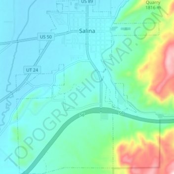
Name: Salina topographic map, elevation, terrain.
Location: Salina, Sevier County, Utah, 84654, United States (38.91446 -111.88771 38.96698 -111.83202)
Average elevation: 1,637 m
Minimum elevation: 1,560 m
Maximum elevation: 1,956 m
Other topographic maps
Click on a map to view its topography, its elevation and its terrain.
Richfield
United States > Utah > Sevier County
Richfield experiences a cold semi-arid climate (Köppen BSk) with four distinct seasons. Winter high temperatures average in the 30s and 40s with many milder days; low temperatures average in the teens and twenties, with a few mornings starting near or below zero. Snowfall is common, but usually melts in a day…
Average elevation: 1,659 m