
Wytheville topographic map
Interactive map
Click on the map to display elevation.
Wytheville
Due to its elevation, the climate of Wytheville is either classified as mountain temperate or humid subtropical (Köppen Cfb or Cfa, respectively), and the town straddles the border between USDA Plant Hardiness Zones 6B and 7A. Summers are warm and humid, although significantly cooler than low-elevation places within the state, with only 4.6 days of 90 °F (32 °C)+ highs annually, and winters are generally cool to cold with occasional intervening warm periods and 11 nights of sub-10 °F (−12 °C) lows. Monthly mean temperatures range from 32.9 °F (0.5 °C) in January to 71.7 °F (22.1 °C) in July. Snowfall averages 20.5 inches (52 cm) per season and generally occurs from December to March.
About this map
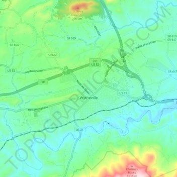
Name: Wytheville topographic map, elevation, terrain.
Location: Wytheville, Wythe County, Virginia, 24382, United States (36.92258 -81.13589 36.98165 -81.03117)
Average elevation: 720 m
Minimum elevation: 621 m
Maximum elevation: 1,059 m
Other topographic maps
Click on a map to view its topography, its elevation and its terrain.
Stones Mill
United States > Virginia > Wythe County > Wytheville > Stones Mill
Average elevation: 710 m