
Puerto Lleras topographic map
Interactive map
Click on the map to display elevation.
About this map
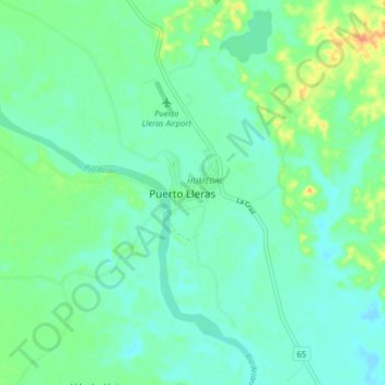
Name: Puerto Lleras topographic map, elevation, terrain.
Location: Puerto Lleras, Meta, Colombia (3.22999 -73.41341 3.30999 -73.33341)
Average elevation: 236 m
Minimum elevation: 224 m
Maximum elevation: 267 m
Other topographic maps
Click on a map to view its topography, its elevation and its terrain.
Puerto Lleras
Colombia > Meta > Puerto Lleras
Puerto Lleras, HUMEDAL, Puerto Lleras, Ariari, Meta, Colombia
Average elevation: 234 m