
Make a donation
Gear up for your next adventure:
As an Amazon Associate, this site earns from qualifying purchases at no extra cost to you.
Niton topographic map
Click on the map to display elevation.
Make a donation
Gear up for your next adventure:
As an Amazon Associate, this site earns from qualifying purchases at no extra cost to you.
About this map
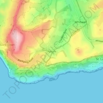
Name: Niton topographic map, elevation, terrain.
Location: Niton, Isle of Wight, England, PO38 2EA, United Kingdom (50.56730 -1.30227 50.60730 -1.26227)
Average elevation: 79 m
Minimum elevation: 0 m
Maximum elevation: 236 m
Isle of Wight trails, hiking, mountain biking, running and outdoor activities
Make a donation
Gear up for your next adventure:
As an Amazon Associate, this site earns from qualifying purchases at no extra cost to you.
Other topographic maps
Click on a map to view its topography, its elevation and its terrain.
Make a donation
Gear up for your next adventure:
As an Amazon Associate, this site earns from qualifying purchases at no extra cost to you.
Ventnor
United Kingdom > England > Isle of Wight
Ventnor's landmarks arise from its natural environment, its Victorian heritage, and its tourist appeal past and present. Although modest in altitude at 241 metres (791 ft), the chalk St Boniface Down is 1⁄2 mile (0.80 km) north of the town. The downs have a thick layer of acid flint gravels, with dry…
Average elevation: 58 m
Bembridge
United Kingdom > England > Isle of Wight
Close to the lifeboat station lies a coastguard lookout. Positioned at a high elevation, this offers views of the Solent meeting the English Channel to the east of the Isle of Wight. From this vantage point one is able to view a variety of watercraft year round, although there is more marine traffic in the…
Average elevation: 9 m
Isle of Wight National Landscape
United Kingdom > England > Isle of Wight > Brighstone
Average elevation: 18 m
Make a donation
Gear up for your next adventure:
As an Amazon Associate, this site earns from qualifying purchases at no extra cost to you.
Make a donation
Gear up for your next adventure:
As an Amazon Associate, this site earns from qualifying purchases at no extra cost to you.
Lake
United Kingdom > England > Isle of Wight
Lake is a seaside village situated above the cliffs on Sandown bay, it stands at an elevation of 63 feet (19 m) above sea-level. Lake's beach or 'Welcome Beach' has golden sands and reached by a steep path down the sandstone cliffs to the Revetment. It has two cafes (Hinks and Strollers), beach huts, a Sea…
Average elevation: 13 m
Make a donation
Gear up for your next adventure:
As an Amazon Associate, this site earns from qualifying purchases at no extra cost to you.
Make a donation
Gear up for your next adventure:
As an Amazon Associate, this site earns from qualifying purchases at no extra cost to you.
Make a donation
Gear up for your next adventure:
As an Amazon Associate, this site earns from qualifying purchases at no extra cost to you.
Make a donation
Gear up for your next adventure:
As an Amazon Associate, this site earns from qualifying purchases at no extra cost to you.