
Arreton topographic map
Interactive map
Click on the map to display elevation.
About this map
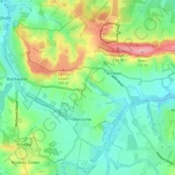
Name: Arreton topographic map, elevation, terrain.
Location: Arreton, Isle of Wight, England, United Kingdom (50.64760 -1.29332 50.69548 -1.21264)
Average elevation: 46 m
Minimum elevation: 6 m
Maximum elevation: 133 m
Isle of Wight trails, hiking, mountain biking, running and outdoor activities
Other topographic maps
Click on a map to view its topography, its elevation and its terrain.
Littleton Down
United Kingdom > England > Isle of Wight > Ventnor > Bonchurch
Average elevation: 111 m
Bowcombe
United Kingdom > England > Isle of Wight
Bowcombe is a hamlet on the Isle of Wight. It has an elevation of 144 feet (44 m) and is located 2+1⁄2 miles (4 km) southwest of Newport in the centre of the Island. Public transport is provided by Southern Vectis buses on route 12.
Average elevation: 82 m