
Kol topographic map
Interactive map
Click on the map to display elevation.
About this map
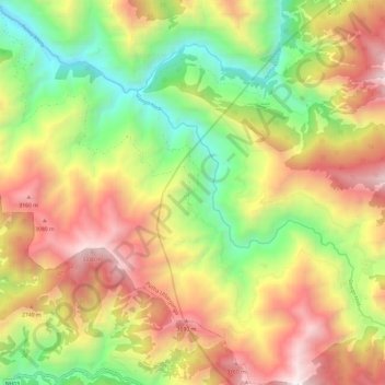
Name: Kol topographic map, elevation, terrain.
Location: Kol, Putha Uttarganga, Eastern Rukum, Lumbini Province, Nepal (28.55221 82.73865 28.65795 82.84800)
Average elevation: 2,347 m
Minimum elevation: 1,379 m
Maximum elevation: 3,445 m
Other topographic maps
Click on a map to view its topography, its elevation and its terrain.
Lukum Khola
Lukum Khola, Bhume-04, Bhume, Eastern Rukum, Nepal
Average elevation: 1,835 m
Rukumkot
Nepal > Eastern Rukum > Sobha > Rukumkot
Rukumkot, Sobha, Sisne, Eastern Rukum, Lumbini Province, Nepal
Average elevation: 1,521 m