
Möckern topographic map
Interactive map
Click on the map to display elevation.
About this map
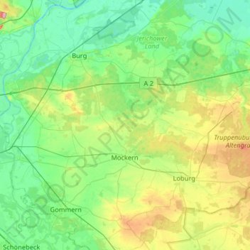
Name: Möckern topographic map, elevation, terrain.
Location: Möckern, Jerichower Land, Saxony-Anhalt, 39279, Germany (52.05727 11.77776 52.30656 12.29714)
Average elevation: 64 m
Minimum elevation: 30 m
Maximum elevation: 171 m
Other topographic maps
Click on a map to view its topography, its elevation and its terrain.
Altengrabow
Germany > Saxony-Anhalt > Jerichower Land > Möckern > Dörnitz
Altengrabow, Dörnitz, Möckern, Jerichower Land, Saxony-Anhalt, 39291, Germany
Average elevation: 90 m
Dörnitz
Germany > Saxony-Anhalt > Jerichower Land > Möckern
Dörnitz, Möckern, Jerichower Land, Saxony-Anhalt, Germany
Average elevation: 91 m
Genthin
Germany > Saxony-Anhalt > Jerichower Land > Genthin > Genthin
Genthin, Jerichower Land, Saxony-Anhalt, 39307, Germany
Average elevation: 36 m