
Make a donation
Gear up for your next adventure:
As an Amazon Associate, this site earns from qualifying purchases at no extra cost to you.
Wedron topographic map
Click on the map to display elevation.
Make a donation
Gear up for your next adventure:
As an Amazon Associate, this site earns from qualifying purchases at no extra cost to you.
About this map
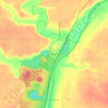
Name: Wedron topographic map, elevation, terrain.
Location: Wedron, LaSalle County, Illinois, 60557, United States (41.41619 -88.79353 41.45619 -88.75353)
Average elevation: 179 m
Minimum elevation: 137 m
Maximum elevation: 201 m
Make a donation
Gear up for your next adventure:
As an Amazon Associate, this site earns from qualifying purchases at no extra cost to you.
Other topographic maps
Click on a map to view its topography, its elevation and its terrain.
Make a donation
Gear up for your next adventure:
As an Amazon Associate, this site earns from qualifying purchases at no extra cost to you.
Make a donation
Gear up for your next adventure:
As an Amazon Associate, this site earns from qualifying purchases at no extra cost to you.
Make a donation
Gear up for your next adventure:
As an Amazon Associate, this site earns from qualifying purchases at no extra cost to you.
Streator
United States > Illinois > LaSalle County
Streator lies within the Vermilion River/Illinois River Basin Assessment Area (VRAA) defined by the watershed of the Vermilion River, a major tributary to the Illinois River in Central Illinois, an area of mostly flat prairie. The topography of the basin is a complex collection of buried valleys, lowlands and…
Average elevation: 191 m
Make a donation
Gear up for your next adventure:
As an Amazon Associate, this site earns from qualifying purchases at no extra cost to you.