Make a donation
Gear up for your next adventure:
As an Amazon Associate, this site earns from qualifying purchases at no extra cost to you.
Hemingstone topographic map
Click on the map to display elevation.
Make a donation
Gear up for your next adventure:
As an Amazon Associate, this site earns from qualifying purchases at no extra cost to you.
About this map
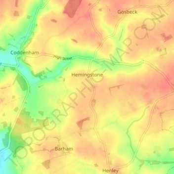
Name: Hemingstone topographic map, elevation, terrain.
Location: Hemingstone, Mid Suffolk, Suffolk, England, United Kingdom (52.12774 1.11015 52.14766 1.17633)
Average elevation: 51 m
Minimum elevation: 18 m
Maximum elevation: 68 m
Suffolk trails, hiking, mountain biking, running and outdoor activities
Make a donation
Gear up for your next adventure:
As an Amazon Associate, this site earns from qualifying purchases at no extra cost to you.
Other topographic maps
Click on a map to view its topography, its elevation and its terrain.
Make a donation
Gear up for your next adventure:
As an Amazon Associate, this site earns from qualifying purchases at no extra cost to you.
Make a donation
Gear up for your next adventure:
As an Amazon Associate, this site earns from qualifying purchases at no extra cost to you.
Make a donation
Gear up for your next adventure:
As an Amazon Associate, this site earns from qualifying purchases at no extra cost to you.
Make a donation
Gear up for your next adventure:
As an Amazon Associate, this site earns from qualifying purchases at no extra cost to you.
Thorpe Street
United Kingdom > England > Suffolk > Mid Suffolk > Hinderclay > Thorpe Street
Average elevation: 36 m
Withersdale Street
United Kingdom > England > Suffolk > Mid Suffolk > Mendham > Withersdale Street
Average elevation: 38 m
Make a donation
Gear up for your next adventure:
As an Amazon Associate, this site earns from qualifying purchases at no extra cost to you.
