
Hays District topographic map
Interactive map
Click on the map to display elevation.
About this map
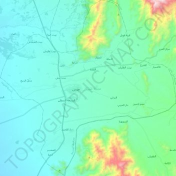
Name: Hays District topographic map, elevation, terrain.
Location: Hays District, Al Hudaydah Governorate, Yemen (13.82455 43.38652 14.04182 43.61027)
Average elevation: 284 m
Minimum elevation: 93 m
Maximum elevation: 1,333 m
Other topographic maps
Click on a map to view its topography, its elevation and its terrain.
Hodeidah
Yemen > Al Hudaydah Governorate
Mountain Highlands: Notable mountains include Jabal Ras and Jabal Bura, both reaching elevations of 2,000 to 2,400 meters above sea level.
Average elevation: 16 m
Hodeidah
Yemen > Al Hudaydah Governorate
Mountain Highlands: Notable mountains include Jabal Ras and Jabal Bura, both reaching elevations of 2,000 to 2,400 meters above sea level.
Average elevation: 16 m