
Make a donation
Gear up for your next adventure:
As an Amazon Associate, this site earns from qualifying purchases at no extra cost to you.
Chesterton topographic map
Click on the map to display elevation.
Make a donation
Gear up for your next adventure:
As an Amazon Associate, this site earns from qualifying purchases at no extra cost to you.
About this map
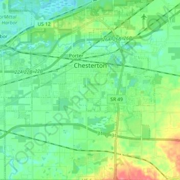
Name: Chesterton topographic map, elevation, terrain.
Location: Chesterton, Porter County, Indiana, 46304, United States (41.55020 -87.12480 41.64485 -87.01881)
Average elevation: 200 m
Minimum elevation: 181 m
Maximum elevation: 250 m
Make a donation
Gear up for your next adventure:
As an Amazon Associate, this site earns from qualifying purchases at no extra cost to you.
Other topographic maps
Click on a map to view its topography, its elevation and its terrain.
Indiana Dunes State Park
United States > Indiana > Porter County > Chesterton
Average elevation: 186 m
Beverly Shores
United States > Indiana > Porter County > Beverly Shores > Beverly Shores
Average elevation: 182 m