
Poanas topographic map
Interactive map
Click on the map to display elevation.
About this map
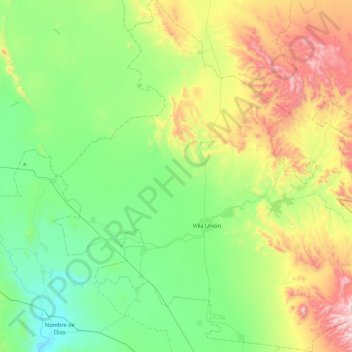
Name: Poanas topographic map, elevation, terrain.
Location: Poanas, Durango, Mexico (23.81974 -104.25336 24.25006 -103.80587)
Average elevation: 2,012 m
Minimum elevation: 1,710 m
Maximum elevation: 2,681 m
Other topographic maps
Click on a map to view its topography, its elevation and its terrain.
Durango
With 123,451.2 km2 or 12.3 million ha, Durango accounts for about 6.3% of the entire territory of Mexico. It is the fourth largest state lying at the extreme northwest of the Central Mexican Plateau, where it meets the Sierra Madre Occidental—the highest peaks in the state. The state has an average elevation…
Average elevation: 1,954 m