Geolocate

Yil topographic map

Interactive map

Click on the map to display elevation.

About this map

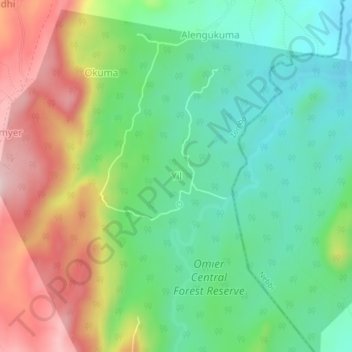
Name: Yil topographic map, elevation, terrain.

Location: Yil, Zombo, Northern Region, Uganda (2.53884 30.97468 2.57884 31.01468)

Average elevation: 1,096 m

Minimum elevation: 962 m

Maximum elevation: 1,317 m

Other topographic maps

Click on a map to view its topography, its elevation and its terrain.

Ngerengere

Uganda > Zombo

Ngerengere, Zombo, Northern Region, Uganda

Average elevation: 1,599 m

Ukok

Uganda > Zombo > Jupaneka

Ukok, Jupaneka, Zombo, Northern Region, Uganda

Average elevation: 1,213 m

Warr TC East

Uganda > Zombo

Warr TC East, Zombo, Northern Region, Uganda

Average elevation: 1,392 m

Athuma

Uganda > Zombo > Athuma

Athuma, Zombo, Northern Region, Uganda

Average elevation: 1,586 m