
Make a donation
Gear up for your next adventure:
As an Amazon Associate, this site earns from qualifying purchases at no extra cost to you.
Cáseda topographic map
Click on the map to display elevation.
Make a donation
Gear up for your next adventure:
As an Amazon Associate, this site earns from qualifying purchases at no extra cost to you.
Cáseda
Muy cerca del río llegan las aguas del Canal de las Bardenas. Viene de Sangüesa y es visible hasta llegar a la falda de San Pedro. Allí, en la boca del túnel, se introduce en el monte y lo atraviesa de lado a lado. Vuelve a surgir y a ocultarse para salvar El Pinar de Cáseda. A la salida de dicha altitud toma dirección a Sofuentes y Cinco Villas (Aragón). Este canal permite regar grandes zonas del sur del término municipal.
Make a donation
Gear up for your next adventure:
As an Amazon Associate, this site earns from qualifying purchases at no extra cost to you.
About this map
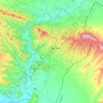
Name: Cáseda topographic map, elevation, terrain.
Location: Cáseda, Comarca de Sangüesa, Navarra, España (42.38146 -1.40638 42.55987 -1.32089)
Average elevation: 518 m
Minimum elevation: 330 m
Maximum elevation: 1,055 m
Make a donation
Gear up for your next adventure:
As an Amazon Associate, this site earns from qualifying purchases at no extra cost to you.
Other topographic maps
Click on a map to view its topography, its elevation and its terrain.
Make a donation
Gear up for your next adventure:
As an Amazon Associate, this site earns from qualifying purchases at no extra cost to you.