
Make a donation
Gear up for your next adventure:
As an Amazon Associate, this site earns from qualifying purchases at no extra cost to you.
Reine topographic map
Click on the map to display elevation.
Make a donation
Gear up for your next adventure:
As an Amazon Associate, this site earns from qualifying purchases at no extra cost to you.
Reine
Allers, the largest weekly magazine in Norway, selected Reine as the most beautiful village in Norway in the late 1970s. A photograph over Reine from the mountain Reinebringen (altitude 448 metres (1,470 ft)) has been used for the front page of several tourist brochures and books. In 1999, the painter Ingo Kühl set up a temporary studio in a rorbu and painted the view over the harbor to the mountain range.
Make a donation
Gear up for your next adventure:
As an Amazon Associate, this site earns from qualifying purchases at no extra cost to you.
About this map
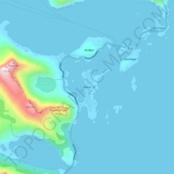
Name: Reine topographic map, elevation, terrain.
Location: Reine, Moskenes, Nordland, 8390, Norway (67.91247 13.06877 67.95247 13.10877)
Average elevation: 58 m
Minimum elevation: -45 m
Maximum elevation: 713 m
Make a donation
Gear up for your next adventure:
As an Amazon Associate, this site earns from qualifying purchases at no extra cost to you.
Other topographic maps
Click on a map to view its topography, its elevation and its terrain.
Bodø
Snow cover during winter varies, and is often sparse or lacking in the city center, while being more reliable only slightly inland or at some altitude. The largest recorded snow depth at the airport is 90 centimetres (35 in) in February 1976. Located on a peninsula in the Norwegian Sea, Bodø is known to be a…
Average elevation: 178 m
Make a donation
Gear up for your next adventure:
As an Amazon Associate, this site earns from qualifying purchases at no extra cost to you.
Make a donation
Gear up for your next adventure:
As an Amazon Associate, this site earns from qualifying purchases at no extra cost to you.
Make a donation
Gear up for your next adventure:
As an Amazon Associate, this site earns from qualifying purchases at no extra cost to you.
Make a donation
Gear up for your next adventure:
As an Amazon Associate, this site earns from qualifying purchases at no extra cost to you.
Make a donation
Gear up for your next adventure:
As an Amazon Associate, this site earns from qualifying purchases at no extra cost to you.
Make a donation
Gear up for your next adventure:
As an Amazon Associate, this site earns from qualifying purchases at no extra cost to you.
Make a donation
Gear up for your next adventure:
As an Amazon Associate, this site earns from qualifying purchases at no extra cost to you.
Make a donation
Gear up for your next adventure:
As an Amazon Associate, this site earns from qualifying purchases at no extra cost to you.
Make a donation
Gear up for your next adventure:
As an Amazon Associate, this site earns from qualifying purchases at no extra cost to you.
Make a donation
Gear up for your next adventure:
As an Amazon Associate, this site earns from qualifying purchases at no extra cost to you.