
Lupembe topographic map
Interactive map
Click on the map to display elevation.
About this map
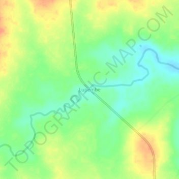
Name: Lupembe topographic map, elevation, terrain.
Location: Lupembe, Haut-Katanga, Democratic Republic of the Congo (-9.98723 28.08555 -9.94723 28.12555)
Average elevation: 995 m
Minimum elevation: 976 m
Maximum elevation: 1,016 m
Other topographic maps
Click on a map to view its topography, its elevation and its terrain.
Solola
Democratic Republic of the Congo > Haut-Katanga > Ville de Lubumbashi > Kampemba
Solola, Kampemba, Ville de Lubumbashi, Haut-Katanga, Democratic Republic of the Congo
Average elevation: 1,228 m
Kasungami
Democratic Republic of the Congo > Haut-Katanga > Ville de Lubumbashi
Kasungami, Annexe, Ville de Lubumbashi, Haut-Katanga, Democratic Republic of the Congo
Average elevation: 1,238 m
Kimbembe
Democratic Republic of the Congo > Haut-Katanga > Ville de Lubumbashi
Kimbembe, Annexe, Ville de Lubumbashi, Haut-Katanga, Democratic Republic of the Congo
Average elevation: 1,261 m
Kasanda
Democratic Republic of the Congo > Haut-Katanga > Ville de Lubumbashi > Matoleo
Kasanda, Matoleo, Ruashi, Ville de Lubumbashi, Haut-Katanga, Democratic Republic of the Congo
Average elevation: 1,303 m
Lubumbashi
Democratic Republic of the Congo > Haut-Katanga > Ville de Lubumbashi
Lubumbashi, Ville de Lubumbashi, Haut-Katanga, Democratic Republic of the Congo
Average elevation: 1,249 m
Météo
Democratic Republic of the Congo > Haut-Katanga > Ville de Lubumbashi > Lubumbashi
Météo, Lubumbashi, Ville de Lubumbashi, Haut-Katanga, Democratic Republic of the Congo
Average elevation: 1,251 m
Bana Katanga
Democratic Republic of the Congo > Haut-Katanga > Ville de Lubumbashi > Bana Katanga
Bana Katanga, Katuba, Ville de Lubumbashi, Haut-Katanga, Democratic Republic of the Congo
Average elevation: 1,201 m
Kundelunga
Democratic Republic of the Congo > Haut-Katanga > Lualaba
Kundelunga, Lualaba, Kenya, Ville de Lubumbashi, Haut-Katanga, Democratic Republic of the Congo
Average elevation: 1,208 m
Kundelungu
Democratic Republic of the Congo > Haut-Katanga > Ville de Lubumbashi > Lubumbashi
Kundelungu, Makutano, Lubumbashi, Ville de Lubumbashi, Haut-Katanga, Democratic Republic of the Congo
Average elevation: 1,243 m
Lubumbashi
Democratic Republic of the Congo > Haut-Katanga > Ville de Lubumbashi > Lubumbashi
Lubumbashi, Makutano, Lubumbashi, Ville de Lubumbashi, Haut-Katanga, 13, Democratic Republic of the Congo
Average elevation: 1,259 m
Likasi
Democratic Republic of the Congo > Haut-Katanga
Likasi, Haut-Katanga, Democratic Republic of the Congo
Average elevation: 1,270 m
Musumba
Democratic Republic of the Congo > Haut-Katanga > Ville de Lubumbashi
Musumba, Katuba, Ville de Lubumbashi, Haut-Katanga, Democratic Republic of the Congo
Average elevation: 1,207 m