
Puntarenas Province topographic map
Interactive map
Click on the map to display elevation.
About this map
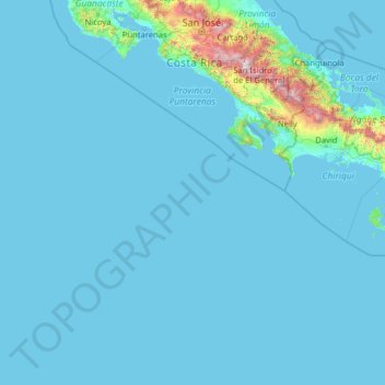
Name: Puntarenas Province topographic map, elevation, terrain.
Location: Puntarenas Province, Costa Rica (5.49916 -87.10200 10.33744 -82.71178)
Average elevation: 118 m
Minimum elevation: 0 m
Maximum elevation: 3,724 m
Other topographic maps
Click on a map to view its topography, its elevation and its terrain.
Cartago
Costa Rica > Cantón Cartago > Oriental
It has an elevation of 1,435 m (4,708 ft) above sea level, at the base of the Irazú Volcano.
Average elevation: 1,706 m
Cruce de Jordan
Costa Rica > Limón Province > Cantón Pococí > Rita > Cruce de Jordan
Average elevation: 114 m