
Latgale topographic map
Interactive map
Click on the map to display elevation.
About this map
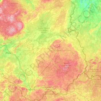
Name: Latgale topographic map, elevation, terrain.
Location: Latgale, Lettonie (55.67465 25.82043 57.37059 28.24149)
Average elevation: 127 m
Minimum elevation: 52 m
Maximum elevation: 285 m
Other topographic maps
Click on a map to view its topography, its elevation and its terrain.
Caunes
Lettonie > Latgale > Līvānu novads > Rudzātu pagasts
Caunes, Rudzātu pagasts, Līvānu novads, Latgale, Lettonie
Average elevation: 102 m
Cibla
Lettonie > Latgale > Ludzas novads
Cibla, Ludzas novads, Latgale, Lettonie
Average elevation: 122 m