
Ludzas novads topographic map
Interactive map
Click on the map to display elevation.
About this map
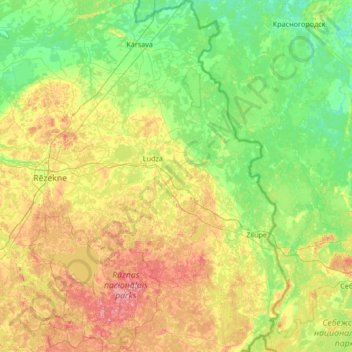
Name: Ludzas novads topographic map, elevation, terrain.
Location: Ludzas novads, Latgale, Lettonie (56.13647 27.34508 56.88013 28.24149)
Average elevation: 135 m
Minimum elevation: 82 m
Maximum elevation: 274 m
Other topographic maps
Click on a map to view its topography, its elevation and its terrain.
Caunes
Lettonie > Latgale > Līvānu novads > Rudzātu pagasts
Caunes, Rudzātu pagasts, Līvānu novads, Latgale, Lettonie
Average elevation: 102 m
Cibla
Lettonie > Latgale > Ludzas novads
Cibla, Ludzas novads, Latgale, Lettonie
Average elevation: 122 m