
Kent County topographic map
Interactive map
Click on the map to display elevation.
About this map
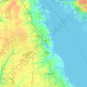
Name: Kent County topographic map, elevation, terrain.
Location: Kent County, Delaware, United States (38.82929 -75.76005 39.38635 -75.13696)
Average elevation: 9 m
Minimum elevation: -4 m
Maximum elevation: 33 m
Other topographic maps
Click on a map to view its topography, its elevation and its terrain.
Meeting House Meadows
United States > Delaware > New Castle County > Hockessin
Average elevation: 95 m
Quaker Hill
United States > Delaware > New Castle County > Hockessin, Delaware
Average elevation: 94 m
Wilmington
United States > Delaware > New Castle County > Wilmington
On the western side of Market Street, the Piedmont topography is rocky and hilly, rising to a point that marks the watershed between the Brandywine River and the Christina River. This watershed line runs along Delaware Avenue westward from 10th Street and Market Street.
Average elevation: 43 m
Runnymeade
United States > Delaware > New Castle County > Hockessin, Delaware > Runnymeade
Average elevation: 92 m
Tree Top Valley
United States > Delaware > New Castle County > Hockessin, Delaware > Tree Top Valley
Average elevation: 93 m