
清徐县 topographic map
Interactive map
Click on the map to display elevation.
About this map
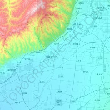
Name: 清徐县 topographic map, elevation, terrain.
Location: 清徐县, 太原市, 山西省, 中国 (37.44142 112.16293 37.78136 112.62041)
Average elevation: 913 m
Minimum elevation: 747 m
Maximum elevation: 1,850 m
Other topographic maps
Click on a map to view its topography, its elevation and its terrain.