
Wokingham topographic map
Interactive map
Click on the map to display elevation.
About this map
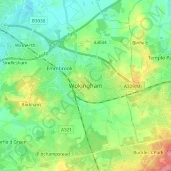
Name: Wokingham topographic map, elevation, terrain.
Location: Wokingham, South East, England, RG40 1TG, United Kingdom (51.37203 -0.87240 51.45203 -0.79240)
Average elevation: 61 m
Minimum elevation: 33 m
Maximum elevation: 126 m
Other topographic maps
Click on a map to view its topography, its elevation and its terrain.
Woose Hill
United Kingdom > England > Wokingham
Woose Hill, Emmbrook, Wokingham, South East England, England, RG41 3DR, United Kingdom
Average elevation: 60 m