
Wilderness Island topographic map
Interactive map
Click on the map to display elevation.
About this map
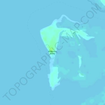
Name: Wilderness Island topographic map, elevation, terrain.
Location: Wilderness Island, Western Australia, Australia (-22.08288 114.51752 -22.06333 114.53273)
Average elevation: 1 m
Minimum elevation: -1 m
Maximum elevation: 12 m
Other topographic maps
Click on a map to view its topography, its elevation and its terrain.
Perth
Australia > Western Australia > City of Perth
Perth, the capital of Western Australia, is situated on the Swan Coastal Plain, a flat expanse of sandy soil nestled between the Indian Ocean to the west and the Darling Scarp to the east. The Darling Scarp, also known as the Darling Range, is a low escarpment that extends north–south, marking a distinct…
Average elevation: 26 m
Kalbarri
Kalbarri is a coastal town in the Mid West region located 592 km (368 mi) north of Perth, Western Australia. The town is located at the mouth of the Murchison River, which has an elevation of 6 metres (20 ft). It is connected by public transport to Perth via Transwa coach services N1 and N2.
Average elevation: 57 m
Rockingham
Rockingham is topographically flat, has sandy soils and coastal vegetation. It has a northern aspect to Cockburn Sound, from Rockingham Beach and Palm Beach.
Average elevation: 4 m
Darlington
Very early on, because of its altitude and separation from the Swan Coastal Plain, Darlington became established as a popular picnic area, country drive destination, and a place for holiday homes.
Average elevation: 154 m
Henley Brook
Henley Brook is situated on the flood plains of the Swan River, with regularly occurring seasonal floods. Two ephemeral streams from the river - Henley Brook and St. Leonard's Creek - traverse the suburb. Henley Brook is in the north-east near Brockman Street, while St Leonards Creek traverses the centre of…
Average elevation: 28 m