Geolocate

Duvall topographic map

Interactive map

Click on the map to display elevation.

About this map

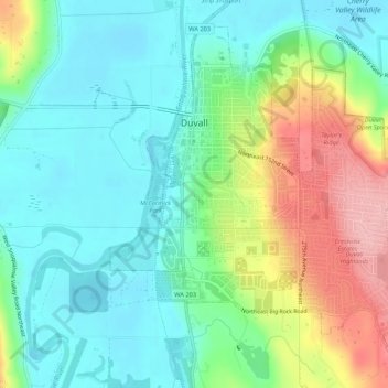
Name: Duvall topographic map, elevation, terrain.

Location: Duvall, King County, Washington, United States (47.72019 -121.99732 47.75123 -121.94390)

Average elevation: 50 m

Minimum elevation: 2 m

Maximum elevation: 153 m

Other topographic maps

Click on a map to view its topography, its elevation and its terrain.

Kenilworth

United States > Washington > King County > Redmond

Average elevation: 66 m

Deer Lake

United States > Washington > King County

Average elevation: 1,153 m

Putrid Pete's Peak

United States > Washington > King County

Average elevation: 1,149 m

Henrys

United States > Washington > King County > Maple Valley

Average elevation: 186 m

Lester

United States > Washington > King County

Lester is located, east of Enumclaw, Washington along the Green River and BNSF Railway line. Its elevation is 1,634 feet (498 m) above sea level.

Average elevation: 690 m

Mount Si

United States > Washington > King County

The peak can be accessed by two trails. The Old Mount Si trail is accessed by the Little Si parking lot and the Boulder Garden Loop. It is 0.6 miles (0.97 km) shorter, 270 feet (82 m) steeper in elevation gain, and less crowded than the main trail. The Mount Si trail is accessed by the Mount Si parking lot.

Average elevation: 787 m

Hilltop

United States > Washington > King County > Bellevue

Average elevation: 194 m

High Point

United States > Washington > King County

Average elevation: 311 m

Factoria

United States > Washington > King County > Bellevue

Average elevation: 75 m

Hot Springs

United States > Washington > King County

Hot Springs is located east of Enumclaw and just west of Lester, along the Green River and BNSF Railway line. Its elevation is 1512 feet (460m) above sea level.

Average elevation: 588 m

Russian Butte

United States > Washington > King County

Average elevation: 977 m

Grotto

United States > Washington > King County

Average elevation: 1,090 m

Long Marsh

United States > Washington > King County

Average elevation: 268 m

Manitou

United States > Washington > King County > Kirkland

Average elevation: 58 m

Riverton

United States > Washington > King County > Tukwila

Average elevation: 77 m

Stevens Pass

United States > Washington > King County

Stevens Pass (elevation 4,061 ft (1,238 m)) is a mountain pass through the Cascade Mountains located at the border of King County and Chelan County in Washington, United States. U.S. Route 2 travels over the pass, reaching a maximum elevation of 4,061 feet (1,238 m). The Pacific Crest Trail crosses the highway…

Average elevation: 1,387 m

Kingsgate

United States > Washington > King County > Kirkland

Average elevation: 68 m

Maury

United States > Washington > King County

Average elevation: 18 m

Hollywood Hill

United States > Washington > King County

Average elevation: 92 m

Kerry Park

United States > Washington > King County > Seattle

Average elevation: 52 m

Mount Si

United States > Washington > King County

The peak can be accessed by two trails. The Old Mount Si trail is accessed by the Little Si parking lot and the Boulder Garden Loop. It is 0.6 miles (0.97 km) shorter, 270 feet (82 m) steeper in elevation gain, and less crowded than the main trail. The Mount Si trail is accessed by the Mount Si parking lot.

Average elevation: 787 m

Mercer Island

United States > Washington > King County > Mercer Island

Mercer Island City Hall is located at 47°34′39″N 122°12′43.2″W / 47.57750°N 122.212000°W / 47.57750; -122.212000 (47.5775, -122.212). The peak elevation in the city is about 338 feet (103 m), near the center of the island.

Average elevation: 39 m

Grotto

United States > Washington > King County

Average elevation: 528 m

Franklin Falls

United States > Washington > King County

Average elevation: 1,017 m

Vashon

United States > Washington > King County

Average elevation: 50 m

Klahanie

United States > Washington > King County > Sammamish

Average elevation: 143 m

Benson Hill

United States > Washington > King County > Renton

Average elevation: 107 m

Totem Lake

United States > Washington > King County > Kirkland

Average elevation: 67 m

Cougar Hills

United States > Washington > King County > Bellevue

Average elevation: 161 m

Nantes Park

United States > Washington > King County > Seattle

Average elevation: 53 m

Lake Hills

United States > Washington > King County > Bellevue

Average elevation: 80 m

Kanaskat

United States > Washington > King County

Average elevation: 330 m

High Point

United States > Washington > King County > Seattle

Average elevation: 88 m

Lemur

United States > Washington > King County > Seattle

Average elevation: 59 m

Somerset

United States > Washington > King County > Bellevue > Somerset

Average elevation: 131 m

Auburn

United States > Washington > King County > Auburn > Auburn

Average elevation: 69 m

Burien

United States > Washington > King County > Burien > Burien

Average elevation: 65 m

Kenmore

United States > Washington > King County > Kenmore > Kenmore

Average elevation: 68 m

Kingsgate

United States > Washington > King County > Kirkland

Average elevation: 68 m

Vasa Park

United States > Washington > King County > Bellevue

Average elevation: 75 m

East Hill

United States > Washington > King County > Kent > East Hill

Average elevation: 108 m

Bothell

United States > Washington > King County > Bothell > Bothell

Average elevation: 67 m

SeaTac

United States > Washington > King County > SeaTac > SeaTac

Average elevation: 65 m

Skyway

United States > Washington > King County > Skyway

Average elevation: 58 m

McVan

United States > Washington > King County > SeaTac > McVan

Average elevation: 102 m