
Kenton County topographic map
Interactive map
Click on the map to display elevation.
Kenton County
According to the United States Census Bureau, the county has a total area of 164 square miles (420 km2), of which 160 square miles (410 km2) is land and 4.1 square miles (11 km2) (2.5%) is water. The county is located at the confluence of the Licking River and Ohio River, in the outer Bluegrass area of the Bluegrass region of the state. The elevation in the county ranges from 455 feet (139 m) to 960 feet (293 m) above sea level.
About this map
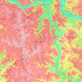
Name: Kenton County topographic map, elevation, terrain.
Location: Kenton County, Kentucky, United States (38.78969 -84.62370 39.09992 -84.41749)
Average elevation: 233 m
Minimum elevation: 135 m
Maximum elevation: 293 m
Other topographic maps
Click on a map to view its topography, its elevation and its terrain.
Mammoth Cave National Park
United States > Kentucky > Edmonson County > Brownsville
The upper sandstone member is known as the Big Clifty Sandstone. Thin, sparse layers of limestone interspersed within the sandstone give rise to an epikarstic zone, in which tiny conduits (cave passages too small to enter) are dissolved by the natural acidity of groundwater. The epikarstic zone concentrates…
Average elevation: 215 m