
Guanajuato topographic map
Interactive map
Click on the map to display elevation.
About this map
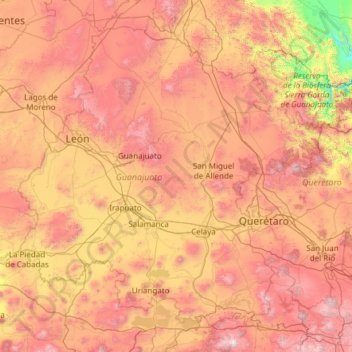
Name: Guanajuato topographic map, elevation, terrain.
Location: Guanajuato, Mexico (19.91275 -102.09728 21.83942 -99.67130)
Average elevation: 2,005 m
Minimum elevation: 873 m
Maximum elevation: 3,508 m
Guanajuato is in the center of Mexico, northwest of Mexico City, bordering Zacatecas, San Luis Potosí, Michoacán, Querétaro, and Jalisco. It is the 20th-largest of Mexico's states, with an area of 30,589 km². It has an average altitude of 2,015 meters (6,611 ft) above sea level, with its territory divided among three of Mexico's physical regions, the Sierra Madre Oriental, the Mexican Plateau and the Trans-Mexican Volcanic Belt. The Sierra Madre Oriental in Guanajuato consists of the Sierra Gorda and the Sierra del Azafrán in the northeast. The Mexican Plateau extends through the center of the state. It is subdivided into various regions parted by low-lying mountain chains such as the Sierra de la Cuatralba and the Sierra de Cubo. The Trans Mexican Volcanic Belt crosses the state in the south and includes the Bajío area, the Altos de Jalisco and the valleys area in the far south. The state is crossed by several mountain ranges with mountains between 2,300 and 3,000 meters high. Mountain ranges average 2,305 meters and flat areas lie at around 1,725 meters above mean sea level. Other important mountain ranges include the Sierra Gorda to the north, the Sierra de Guanajuato in the southeast, the Comanja in the northwest and the Codorniz in the east.
Other topographic maps
Click on a map to view its topography, its elevation and its terrain.
Cabo San Lucas
Mexico > Baja California Sur > Los Cabos Municipality
Cabo San Lucas, Los Cabos Municipality, Baja California Sur, 23470, Mexico
Average elevation: 94 m
Cancún
Mexico > Quintana Roo > Benito Juárez
Cancún, Benito Juárez, Quintana Roo, Mexico
Average elevation: 5 m
San Miguel de Allende
Mexico > Guanajuato > San Miguel de Allende
San Miguel de Allende, Guanajuato, Mexico
Average elevation: 1,964 m
San Cristóbal
Mexico > Chiapas > San Cristóbal de las Casas
San Cristóbal, San Cristóbal de las Casas, Chiapas, 29200, Mexico
Average elevation: 2,038 m
Cedros Island
Mexico > Baja California > Municipio de Ensenada
Cedros Island, Municipio de Ensenada, Baja California, 22990, Mexico
Average elevation: 67 m
Querétaro
Mexico > Querétaro > Municipio de Querétaro
Querétaro, Municipio de Querétaro, Querétaro, Mexico
Average elevation: 1,921 m
Tepeji del Río de Ocampo
Tepeji del Río de Ocampo, Hidalgo, Mexico
Average elevation: 2,296 m
Malinche
Mexico > Tlaxcala > Teolocholco
Malinche, Teolocholco, Tlaxcala, Mexico
Average elevation: 3,911 m
Yucatán Peninsula
Mexico > Quintana Roo > Othón P. Blanco
Yucatán Peninsula, Othón P. Blanco, Quintana Roo, Mexico
Average elevation: 100 m
San Juan Colorado
Mexico > Oaxaca > San Juan Colorado
San Juan Colorado, Oaxaca, 71750, Mexico
Average elevation: 412 m
San Miguel
Mexico > Nuevo León > García
San Miguel, García, Nuevo León, Mexico
Average elevation: 1,431 m
Jesús del Monte
Jesús del Monte, Morelia, Michoacán, 58350, Mexico
Average elevation: 2,136 m
Casas Grandes
Mexico > Chihuahua > Casas Grandes
Casas Grandes, Chihuahua, 31850, Mexico
Average elevation: 1,503 m
Sierra Negra
Mexico > Puebla > Chalchicomula de Sesma
Sierra Negra, Chalchicomula de Sesma, Puebla, Mexico
Average elevation: 4,099 m
Llano Hermoso
Mexico > Durango > Nuevo Ideal
Llano Hermoso, Nuevo Ideal, Durango, Mexico
Average elevation: 1,967 m
Guadalajara
Mexico > Jalisco > Guadalajara
Guadalajara, Jalisco, 44360, Mexico
Average elevation: 1,572 m
Isla Cozumel
Mexico > Quintana Roo > Cozumel
Isla Cozumel, Cozumel, Quintana Roo, Mexico
Average elevation: 2 m
Río Blanco
Río Blanco, Zapopan, Región Centro, Jalisco, 45158, Mexico
Average elevation: 1,575 m
Puerto Vallarta
Mexico > Jalisco > Puerto Vallarta
Puerto Vallarta, Región Costa Norte, Jalisco, 48300, Mexico
Average elevation: 306 m
Ventanilla
Mexico > Oaxaca > Santa María Colotepec
Ventanilla, Santa María Colotepec, Oaxaca, 70937, Mexico
Average elevation: 79 m
Santa Cruz Cuautomatitla
Mexico > Puebla > Tochimilco
Santa Cruz Cuautomatitla, Tochimilco, Puebla, Mexico
Average elevation: 2,492 m
Tijuana
Mexico > Baja California > Municipio de Tijuana
Tijuana, Municipio de Tijuana, Baja California, 22320, Mexico
Average elevation: 141 m
San Clemente de Terapa
San Clemente de Terapa, Moctezuma, Sonora, Mexico
Average elevation: 618 m
Colinas de San Miguel
Mexico > Sinaloa > Culiacán > Culiacán Rosales
Colinas de San Miguel, Culiacán Rosales, Culiacán, Sinaloa, 80228, Mexico
Average elevation: 94 m
San Miguel (Cíbolas de Mar)
Mexico > Baja California > Municipio de Ensenada > Ensenada
San Miguel (Cíbolas de Mar), Ensenada, Municipio de Ensenada, Baja California, 22760, Mexico
Average elevation: 57 m
Las Cuevas
Mexico > Durango > Tlahualilo
Las Cuevas, Tlahualilo, Durango, Mexico
Average elevation: 1,136 m
Llano Grande
Mexico > Sinaloa > Municipio de Sinaloa
Llano Grande, Municipio de Sinaloa, Sinaloa, 81991, Mexico
Average elevation: 157 m
Copper Canyon
Copper Canyon, Ruta Panoramica, El Aguaje, Urique, Chihuahua, Mexico
Average elevation: 1,619 m
La Ventana
Mexico > Baja California Sur > Municipio de La Paz
La Ventana, Municipio de La Paz, Baja California Sur, 23232, Mexico
Average elevation: 28 m