
Erawan topographic map
Interactive map
Click on the map to display elevation.
About this map
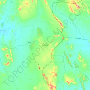
Name: Erawan topographic map, elevation, terrain.
Location: Erawan, Loei Province, Thailand (17.14107 101.79593 17.46107 102.11593)
Average elevation: 320 m
Minimum elevation: 250 m
Maximum elevation: 661 m
Other topographic maps
Click on a map to view its topography, its elevation and its terrain.
Ban Kliang
Ban Kliang, Na Haeo, Loei Province, Thailand
Average elevation: 571 m
Phu Kradueng
Thailand > Loei Province > Phu Kradueng
Phu Kradueng, Loei Province, 42180, Thailand
Average elevation: 264 m