
Harlan County topographic map
Interactive map
Click on the map to display elevation.
Harlan County
Black Mountain, located east of Lynch, is Kentucky's highest point, with an elevation of 4,145 feet (1,263 m) above sea level.
About this map
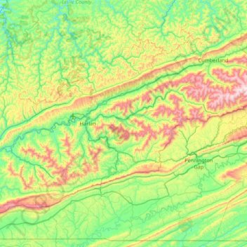
Name: Harlan County topographic map, elevation, terrain.
Location: Harlan County, Kentucky, United States (36.66475 -83.51173 37.02121 -82.85587)
Average elevation: 560 m
Minimum elevation: 271 m
Maximum elevation: 1,238 m
Other topographic maps
Click on a map to view its topography, its elevation and its terrain.
Mammoth Cave National Park
United States > Kentucky > Edmonson County > Brownsville
The upper sandstone member is known as the Big Clifty Sandstone. Thin, sparse layers of limestone interspersed within the sandstone give rise to an epikarstic zone, in which tiny conduits (cave passages too small to enter) are dissolved by the natural acidity of groundwater. The epikarstic zone concentrates…
Average elevation: 215 m