
Make a donation
Gear up for your next adventure:
As an Amazon Associate, this site earns from qualifying purchases at no extra cost to you.
Jerteh topographic map
Click on the map to display elevation.
Gear up for your next adventure:
As an Amazon Associate, this site earns from qualifying purchases at no extra cost to you.
About this map
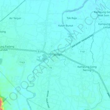
Name: Jerteh topographic map, elevation, terrain.
Location: Jerteh, Besut, Terengganu, 22000, Malaysia (5.69814 102.45715 5.77814 102.53715)
Average elevation: 12 m
Minimum elevation: 1 m
Maximum elevation: 66 m
Make a donation
Gear up for your next adventure:
As an Amazon Associate, this site earns from qualifying purchases at no extra cost to you.
Other topographic maps
Click on a map to view its topography, its elevation and its terrain.
Make a donation
Gear up for your next adventure:
As an Amazon Associate, this site earns from qualifying purchases at no extra cost to you.
Make a donation
Gear up for your next adventure:
As an Amazon Associate, this site earns from qualifying purchases at no extra cost to you.
Make a donation
Gear up for your next adventure:
As an Amazon Associate, this site earns from qualifying purchases at no extra cost to you.
Duyung Small Island
Malaysia > Terengganu > Kuala Terengganu > Kuala Terengganu
Average elevation: 4 m
Pak Mat Lebai Island
Malaysia > Terengganu > Kuala Terengganu > Kuala Terengganu
Average elevation: 6 m
Make a donation
Gear up for your next adventure:
As an Amazon Associate, this site earns from qualifying purchases at no extra cost to you.
Make a donation
Gear up for your next adventure:
As an Amazon Associate, this site earns from qualifying purchases at no extra cost to you.
Batu Burok Public Park
Malaysia > Terengganu > Kuala Terengganu > Kuala Terengganu
Average elevation: 5 m
Make a donation
Gear up for your next adventure:
As an Amazon Associate, this site earns from qualifying purchases at no extra cost to you.
Marang
Marang has an area of 666 km². The district's topography consists of the South China Sea coast, peat swamps, hills and plains. The sub-districts (Malay: mukim) of Rusila, Pulau Kerengga and Merchang lie on the coast with sandy plains gradually giving way to hills in the interior. The Jerong sub-district is…
Average elevation: 30 m
Marang
Marang has an area of 666 km2. The district's topography consists of the South China Sea coast, peat swamps, hills and plains. The sub-districts (Malay: mukim) of Rusila, Pulau Kerengga and Merchang lie on the coast with sandy plains gradually giving way to hills in the interior. The Jerong sub-district is…
Average elevation: 30 m
Make a donation
Gear up for your next adventure:
As an Amazon Associate, this site earns from qualifying purchases at no extra cost to you.
Taman Tamadun Islam (Mini Islam)
Malaysia > Terengganu > Kuala Terengganu > Kuala Terengganu
Average elevation: 5 m
Make a donation
Gear up for your next adventure:
As an Amazon Associate, this site earns from qualifying purchases at no extra cost to you.
Make a donation
Gear up for your next adventure:
As an Amazon Associate, this site earns from qualifying purchases at no extra cost to you.
Make a donation
Gear up for your next adventure:
As an Amazon Associate, this site earns from qualifying purchases at no extra cost to you.
Make a donation
Gear up for your next adventure:
As an Amazon Associate, this site earns from qualifying purchases at no extra cost to you.
Sungai Kandang Rusa
Malaysia > Terengganu > Kemaman District > Kampung Semayor
Average elevation: 32 m
Make a donation
Gear up for your next adventure:
As an Amazon Associate, this site earns from qualifying purchases at no extra cost to you.