
Sungai Dungun topographic map
Interactive map
Click on the map to display elevation.
About this map
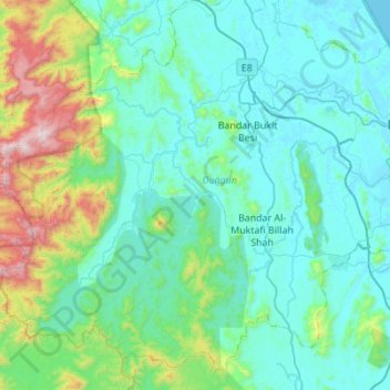
Name: Sungai Dungun topographic map, elevation, terrain.
Location: Sungai Dungun, Terengganu, Malaysia (4.47917 102.87901 4.84969 103.42942)
Average elevation: 231 m
Minimum elevation: -1 m
Maximum elevation: 1,531 m
Other topographic maps
Click on a map to view its topography, its elevation and its terrain.
Kuala Terengganu
Malaysia > Terengganu > Kuala Terengganu
As a part of Terengganu, Kuala Terengganu has a tropical rainforest climate under the Köppen climate classification (Af) with constant temperature and high humidity. The amount of rainfall varies according to the monsoon season. It is generally fairly hot and humid all year round, averaging from 28 °C to 30…
Average elevation: 9 m
Bukit Pelanduk
Malaysia > Terengganu > Kemaman District > Kampung Teluk Kalong
Average elevation: 19 m
Marang
Marang has an area of 666 km². The district's topography consists of the South China Sea coast, peat swamps, hills and plains. The sub-districts (Malay: mukim) of Rusila, Pulau Kerengga and Merchang lie on the coast with sandy plains gradually giving way to hills in the interior. The Jerong sub-district is…
Average elevation: 30 m
Marang
Marang has an area of 666 km2. The district's topography consists of the South China Sea coast, peat swamps, hills and plains. The sub-districts (Malay: mukim) of Rusila, Pulau Kerengga and Merchang lie on the coast with sandy plains gradually giving way to hills in the interior. The Jerong sub-district is…
Average elevation: 30 m