
Senj topographic map
Interactive map
Click on the map to display elevation.
About this map
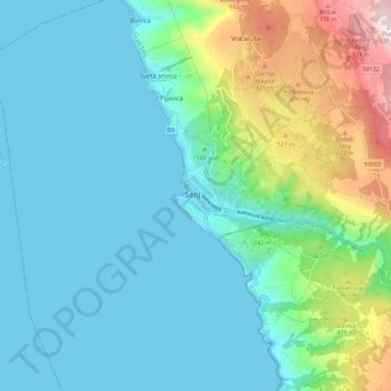
Name: Senj topographic map, elevation, terrain.
Location: Senj, Grad Senj, Lika-Senj County, 52370, Croatia (44.95015 14.86212 45.03015 14.94212)
Average elevation: 191 m
Minimum elevation: 0 m
Maximum elevation: 921 m
Other topographic maps
Click on a map to view its topography, its elevation and its terrain.
Plitvice Lakes National Park
The 16 lakes are separated into an upper and lower cluster formed by runoff from the mountains, descending from an altitude of 636 to 503 m (2,087 to 1,650 ft) over a distance of some 8 kilometres (5.0 mi), aligned in a south–north direction. The lakes collectively cover an area of about 0.77 square miles,…
Average elevation: 765 m
Otočac
Otočac is located in the western part of Gacko Polje, the karst field of centrally located Gacka river, located between Velebit and Mala Kapela, at an elevation of 459m. The town lies to the southeast of Senj, northwest of Gospić and west of Plitvice.
Average elevation: 511 m
Perušić
The Municipality of Perušić is located in the southeastern part of Lika, at an altitude of 575–600 metres (1,886–1,969 ft), in a valley of the Lika River watershed. It lies in a field, Perušićko polje, bounded by the hills west of Klis and the railway line east of the Old Town of Perušić (Stari grad…
Average elevation: 608 m
Plitvice Lakes National Park
The afforested mountain slopes serve as water reservoirs. They are also a refuge for many animal species. The large difference in altitude in a narrow space between the mountains in the south and the Korana river in the north also represents a significant criterion for biodiversity in this region. The overall…
Average elevation: 765 m