
Hamirpur topographic map
Interactive map
Click on the map to display elevation.
About this map
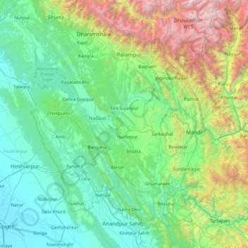
Name: Hamirpur topographic map, elevation, terrain.
Location: Hamirpur, Himachal Pradesh, 177005, India (31.04913 75.80368 32.44913 77.20368)
Average elevation: 1,303 m
Minimum elevation: 232 m
Maximum elevation: 6,070 m
Other topographic maps
Click on a map to view its topography, its elevation and its terrain.
Shikari Devi Wildlife Sanctuary
India > Himachal Pradesh > Thunag > Sangalwara
Average elevation: 2,518 m
Kangra
Dhauladhar Wildlife Sanctuary is located at an altitude of 1600 m going up to 4400 m, Dhauladhar Wildlife Sanctuary was established in 1994 by the Wildlife Department of Himachal Pradesh Government. It is situated in Kangra district. The wildlife sanctuary is covered by snow-clad mountains from three sides.…
Average elevation: 1,504 m
Lahaul and Spiti
The two valleys are quite different in character. Spiti is more barren and difficult to cross, with an average elevation of the valley floor of 4,270 m (14,010 ft). It is enclosed between lofty ranges, with the Spiti river rushing out of a gorge in the southeast to meet the Sutlej River. It is a typical…
Average elevation: 4,281 m
Kinnaur District
A mountainous area, ranging in altitude from 2,320 to 6,816 metres (7,612 to 22,362 ft), Kinnaur is one of the smallest districts in India by population. It is known for the Kinnaur Kailash, a mountain sacred to Hindus, close to the Chinese border.
Average elevation: 4,303 m
Bilaspur
The district lies in the outer foothills of the Himalayas, at the point where they meet the Punjab plains. There are no major mountains in the district, and the overall elevation isn't especially high, but the terrain is very hilly. Flat land is restricted to narrow areas along rivers and streams. The main…
Average elevation: 922 m
Bir
India > Himachal Pradesh > Bir
The paragliding launch site is in the meadow at Billing (14 km north of Bir), at an elevation of 2400 metres, while the landing site and most tourist accommodations are in the village of Chowgan (also spelled Chaugan), on the southern edge of Bir.
Average elevation: 1,616 m