Geolocate

Vila do Topo topographic map

Interactive map

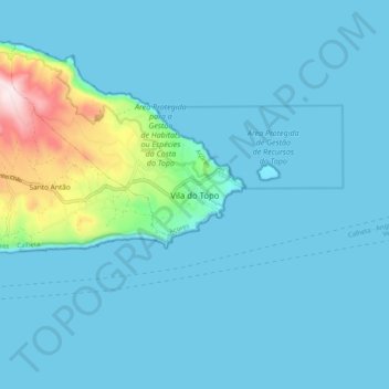
Click on the map to display elevation.

About this map

Name: Vila do Topo topographic map, elevation, terrain.

Location: Vila do Topo, Calheta, Azores, 9875-168, Portugal (38.50629 -27.80582 38.58629 -27.72582)

Average elevation: 60 m

Minimum elevation: 0 m

Maximum elevation: 575 m

Other topographic maps

Click on a map to view its topography, its elevation and its terrain.

Madeira

Portugal

The archipelago includes the islands of Madeira, Porto Santo, and the Desertas, administered together with the separate archipelago of the Savage Islands. Roughly half of the region's population lives in its capital, Funchal. The region has political and administrative autonomy through the Administrative…

Average elevation: 5 m

São Miguel Island

Portugal

The highest elevation on São Miguel is the Pico da Vara at 1,103 metres (3,619 ft). Lying at the eastern end of the island, it is the focus of a Special Protection Area containing the largest remnant of laurisilva forest on the island, which is home to the endemic and critically endangered bird, the Azores…

Average elevation: 61 m

Lisbon

Portugal > Área Metropolitana de Lisboa > Lisbon

Average elevation: 110 m

Azores

Portugal

The same can not be said for the higher altitudes (e.g. Mount Pico), where upper air masses of a continental origin and with a more direct pathway can reach the surface and present those areas with drier air and more extreme temperatures. At the same time, this free atmosphere circulating air transports…

Average elevation: 2 m

Algarve

Portugal

The Algarve is located in the southernmost area of continental Portugal and the southwesternmost area of the Iberian Peninsula and mainland Europe, covering an area of 4,997 km2 (1,929 sq mi). It borders to the north with the Alentejo region (Alentejo Litoral and Baixo Alentejo), to the south and west with the…

Average elevation: 99 m

Lisbon

Portugal > Lisbon

Average elevation: 51 m

Freixo

Portugal > Viana do Castelo > Ponte de Lima

Average elevation: 173 m

Trofa

Portugal > Porto

Average elevation: 115 m

Redinha

Portugal > Leiria > Pombal

Average elevation: 165 m

Porto

Portugal > Porto

Average elevation: 77 m

Pinhão

Portugal > Vila Real

Average elevation: 217 m

Moreira

Portugal > Porto

Average elevation: 78 m

Savage Islands

Portugal > Funchal

Average elevation: 1 m

Mondim de Basto

Portugal > Vila Real

Average elevation: 479 m

Celorico de Basto

Portugal > Braga

Average elevation: 422 m

Sintra

Portugal > Lisbon > Sintra

Average elevation: 175 m

Vilar Seco

Portugal > Bragança > Vimioso

Average elevation: 740 m

Águas Frias

Portugal > Vila Real > Chaves

Average elevation: 719 m

Cruz

Portugal > Braga > Vila Nova de Famalicão

Average elevation: 177 m

Praia do Carvalho

Portugal > Faro > Lagoa

Average elevation: 25 m

Lamas

Portugal > Lisbon > Cadaval

Average elevation: 203 m

Nelas

Portugal > Viseu

Situated within the Centro region, the municipality is located on the Beirão plateau, surrounded in the south and east by the Serra da Estrela, the Serra Açor, and the Serra da Lousã mountain ranges; to the west the Serra do Bussaco, Serra do Caramulo, Serra da Freita and Serra do Montemurro. To the…

Average elevation: 363 m

Cascais

Portugal > Lisbon

The settlement's prosperity led to its administrative independence from Sintra in 1364. On 7 June 1364, the people of Cascais obtained from King Peter I the elevation of the village to the status of town, necessitating the appointment of local judges and administrators. The townspeople were consequently…

Average elevation: 87 m

Fuseta

Portugal > Faro > Olhão

Average elevation: 5 m

Santa Cruz da Graciosa

Portugal

Average elevation: 65 m

Rio Maior

Portugal > Santarém

Average elevation: 127 m

Venda Nova e Pondras

Portugal > Vila Real > Montalegre

Average elevation: 858 m

Faro

Portugal

Average elevation: 99 m

Parque Laudato Si

Portugal > Lisbon > Lisbon

Average elevation: 98 m

Sesimbra

Portugal > Setúbal

Average elevation: 69 m

Campo de Ourique

Portugal > Lisbon > Lisbon

Average elevation: 76 m

Souto da Casa

Portugal > Castelo Branco > Fundão

Average elevation: 727 m

Salto

Portugal > Vila Real

Average elevation: 912 m

Ferral

Portugal > Vila Real > Montalegre

Average elevation: 614 m

Fratel

Portugal > Castelo Branco > Vila Velha de Ródão

Average elevation: 223 m

Montalegre e Padroso

Portugal > Vila Real > Montalegre

Average elevation: 1,068 m

Setúbal

Portugal > Setúbal

Average elevation: 35 m

Louredo

Portugal > Braga > Póvoa de Lanhoso

Average elevation: 293 m

Morgade

Portugal > Vila Real > Montalegre

Average elevation: 920 m

Ladoeiro

Portugal > Castelo Branco > Idanha-a-Nova

Average elevation: 213 m

Vieira do Minho

Portugal > Braga

Average elevation: 526 m

Portimão

Portugal > Faro

The geographical distribution of the altitude and relief of the municipality of Portimão generically follow the three types of territory present in the Barlavento: the coastal region, the Barrocal (a region between the coastal region and the mountains) and the mountains up north. Each one with their own…

Average elevation: 67 m

Nogueira

Portugal > Bragança > Bragança

Average elevation: 823 m

Avis

Portugal > Portalegre

Average elevation: 176 m

Peneda-Gerês National Park

Portugal > Viana do Castelo

During the Pleistocene (approximately 1.8 to 0.001 Ma ago) climatic variations resulted in an extension of glacial fields to the mid-latitudes. While there are no remnants of glaciers now, their Ice Age products (U-shaped valleys, moraines, glacial deposits, polished and natural granite surfaces) are…

Average elevation: 629 m

Mangualde

Portugal > Viseu

On 3 July 1986, the Portuguese Assembly ratified the elevation of the town to the category of city.

Average elevation: 443 m

Monsaraz

Portugal > Évora > Reguengos de Monsaraz

Average elevation: 180 m

Marvão

Portugal > Portalegre

Average elevation: 493 m

Guarda

Portugal

Average elevation: 673 m

Cacia

Portugal > Aveiro > Aveiro

Average elevation: 11 m

Ilha Graciosa

Portugal > Guadalupe

The interior of the island is generally flat and dotted by numerous volcanic cones, with a southern portion of the island higher in altitude. The island is divided into four geomorphological zones.

Average elevation: 65 m

Belver

Portugal > Portalegre > Gavião

The parish is situated in river valley, 500 metres (1,600 ft) from the right margin of the Tagus River, along the confluence of the Ribeira de Belver. Its highest elevation is occupied by the 150 metres (490 ft) hilltop surmounted by the Castle of Belver, while the urban area is 125 metres (410 ft) above sea…

Average elevation: 209 m

Foz do Sousa

Portugal > Porto > Gondomar

Average elevation: 80 m

Amoreira

Portugal > Leiria > Óbidos

Average elevation: 46 m

Lamosa

Portugal > Viseu

Average elevation: 817 m

Olhão

Portugal > Faro

Over time the small town of fishermen grew into an economic, social and urban centre, resulting in its elevation in city in 1985. In recent years, it has also developed a growing tourist industry.

Average elevation: 69 m

Fafe

Portugal > Braga

Average elevation: 450 m

Ilha do Corvo

Portugal > Vila do Corvo

The island is located on the North American Plate, west of the Mid-Atlantic Ridge on a sea-mount of approximately 1.5-1.0 million years age. The islands of Corvo and Flores emerged from a submarine mount oriented along a north-northeast to south-southwest line, while Corvo is controlled by faults oriented…

Average elevation: 148 m

Espinhel

Portugal > Aveiro > Águeda

Average elevation: 38 m

Escapães

Portugal > Aveiro > Santa Maria da Feira

Average elevation: 227 m

Lagos

Portugal > Faro

Average elevation: 57 m

Nesperal

Portugal > Castelo Branco > Sertã

Average elevation: 319 m

Corvo

Portugal

Average elevation: 148 m

Terras de Bouro

Portugal > Braga

Average elevation: 405 m

Lapas

Portugal > Santarém > Torres Novas

Average elevation: 80 m

Amonde

Portugal > Viana do Castelo > Viana do Castelo

Average elevation: 198 m

Calheta

Portugal

Average elevation: 509 m

Moita

Portugal > Setúbal

Average elevation: 19 m

Oliveirinha

Portugal > Aveiro > Aveiro

Average elevation: 46 m

Espinho

Portugal > Aveiro

Average elevation: 28 m

Quintela

Portugal > Viseu

Average elevation: 846 m

Furadouro

Portugal > Coimbra > Condeixa-a-Nova

Average elevation: 236 m

Valongo

Portugal > Porto

Average elevation: 155 m

Vez river

Portugal > Viana do Castelo

Average elevation: 474 m

Vila de Rei

Portugal > Castelo Branco

At the small town of Vila de Rei, it is worth admiring the 18th century Parish Church and the Miserichord Chapel. A natural curiosity of Vila de Rei is the Penedo Furado (pierced boulder), which has been adapted to shelter two belvederes, set on a rocky platform surrounded by woods and small water-falls. The…

Average elevation: 281 m

Oeiras

Portugal > Lisbon

Average elevation: 69 m

Bico

Portugal > Braga > Amares

Average elevation: 68 m

Silva

Portugal > Braga > Barcelos

Average elevation: 94 m

Odivelas

Portugal > Lisbon

Average elevation: 116 m

Covas

Portugal > Braga > Vila Verde

Average elevation: 300 m

Meadela

Portugal > Viana do Castelo > Viana do Castelo

Average elevation: 40 m

Campo do Gerês

Portugal > Braga > Terras de Bouro

Average elevation: 760 m

Salão

Portugal

Average elevation: 323 m

Almeirim

Portugal > Santarém

Average elevation: 44 m

Achada

Portugal

Average elevation: 425 m

Sopo

Portugal > Viana do Castelo > Vila Nova de Cerveira

Average elevation: 215 m

Mafra

Portugal > Lisbon

Average elevation: 126 m

Pedrógão Grande

Portugal > Leiria

Average elevation: 447 m