
La Massana topographic map
Interactive map
Click on the map to display elevation.
About this map
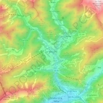
Name: La Massana topographic map, elevation, terrain.
Location: La Massana, AD400, Andorra (42.50420 1.47638 42.58420 1.55638)
Average elevation: 1,667 m
Minimum elevation: 998 m
Maximum elevation: 2,718 m
Coma Pedrosa in the north-west of the parish is the highest point in the Principality of Andorra at 2,942 metres (9,652 ft), and has panoramic views of the Pyrenees. The mountain is also the site of the Coma Pedrosa Nature Reserve. It is covered by heavy snowfalls in winter, and usually retains some snow cover in summer. The four next-highest peaks are Medacorba (2914 m), Sanfonts (2888 m), Pla de l'Estany (2859 m), and Racofred (2837 m). The town of La Massana has an average elevation of 1,240 metres (4,070 ft) above sea-level. There are four lakes: Forcats, Montmantell, Estany Negre, and Les Truites Lake.
Other topographic maps
Click on a map to view its topography, its elevation and its terrain.