
Carter County topographic map
Click on the map to display elevation.
About this map
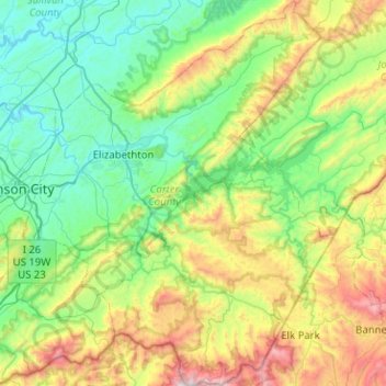
Name: Carter County topographic map, elevation, terrain.
Location: Carter County, East Tennessee, Tennessee, United States (36.10313 -82.34261 36.51086 -81.93299)
Average elevation: 814 m
Minimum elevation: 416 m
Maximum elevation: 1,903 m
Other topographic maps
Click on a map to view its topography, its elevation and its terrain.
Ocoee
United States > Tennessee > Polk County
Its elevation is 797 feet (243 m), and it is located at 35°7′28″N 84°43′6″W / 35.12444°N 84.71833°W / 35.12444; -84.71833 (35.1245194, -84.7181327). Ocoee is located at the intersection of US 64/US 74 and US 411. The Ocoee River flows nearby.
Average elevation: 245 m
Barfield Crescent Park
United States > Tennessee > Rutherford County > Murfreesboro
Average elevation: 201 m
Edwin Warner Park
United States > Tennessee > Davidson County > Nashville > Devonshire Manor
Average elevation: 198 m
Ellington Agricultural Center
United States > Tennessee > Davidson County > Nashville
Average elevation: 178 m
Eastdale
United States > Tennessee > Hamilton County > Chattanooga > Ridgeside
Average elevation: 237 m
Ridgedale
United States > Tennessee > Hamilton County > Chattanooga > Ridgeside
Average elevation: 234 m